You are here: Home > Network List > O2 - Oklahoma Consolidated Temporary Seismic Networks Stations List
> Station DRIP Dripping spring state park, Oklahoma, USA > Earthquake Result Viewer
DRIP Dripping spring state park, Oklahoma, USA - Earthquake Result Viewer
| Earthquake location: |
Northern Chile |
| Earthquake latitude/longitude: |
-23.4/-68.5 |
| Earthquake time(UTC): |
2020/06/03 (155) 07:35:34 GMT |
| Earthquake Depth: |
138 km |
| Earthquake Magnitude: |
6.8 Mi |
| Earthquake Catalog/Contributor: |
NEIC PDE/at |
|
| Network: |
O2 Oklahoma Consolidated Temporary Seismic Networks |
| Station: |
DRIP Dripping spring state park, Oklahoma, USA |
| Lat/Lon: |
35.61 N/96.07 W |
| Elevation: |
243 m |
|
| Distance: |
64.2 deg |
| Az: |
335.248 deg |
| Baz: |
151.831 deg |
| Ray Param: |
0.05866727 |
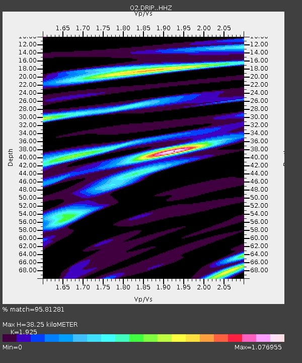
| Estimated Moho Depth: |
38.25 km |
| Estimated Crust Vp/Vs: |
1.92 |
| Assumed Crust Vp: |
6.426 km/s |
| Estimated Crust Vs: |
3.338 km/s |
| Estimated Crust Poisson's Ratio: |
0.32 |
|
| Radial Match: |
95.81281 % |
| Radial Bump: |
336 |
| Transverse Match: |
85.966866 % |
| Transverse Bump: |
400 |
| SOD ConfigId: |
21166931 |
| Insert Time: |
2020-06-17 07:47:23.514 +0000 |
| GWidth: |
2.5 |
| Max Bumps: |
400 |
| Tol: |
0.001 |
|

Signal To Noise
| Channel | StoN | STA | LTA |
| O2:DRIP: :HHZ:20200603T07:45:23.494995Z | 7.519392 | 6.8266235E-7 | 9.0786905E-8 |
| O2:DRIP: :HHN:20200603T07:45:23.494995Z | 1.9914962 | 2.3147895E-7 | 1.1623369E-7 |
| O2:DRIP: :HHE:20200603T07:45:23.494995Z | 1.4201003 | 1.3861228E-7 | 9.760738E-8 |
| Arrivals |
| Ps | 5.7 SECOND |
| PpPs | 17 SECOND |
| PsPs/PpSs | 22 SECOND |


