You are here: Home > Network List > O2 - Oklahoma Consolidated Temporary Seismic Networks Stations List
> Station MRSH Marshall, Oklahoma, USA > Earthquake Result Viewer
MRSH Marshall, Oklahoma, USA - Earthquake Result Viewer
| Earthquake location: |
Northern Chile |
| Earthquake latitude/longitude: |
-23.4/-68.5 |
| Earthquake time(UTC): |
2020/06/03 (155) 07:35:34 GMT |
| Earthquake Depth: |
138 km |
| Earthquake Magnitude: |
6.8 Mi |
| Earthquake Catalog/Contributor: |
NEIC PDE/at |
|
| Network: |
O2 Oklahoma Consolidated Temporary Seismic Networks |
| Station: |
MRSH Marshall, Oklahoma, USA |
| Lat/Lon: |
36.13 N/97.70 W |
| Elevation: |
309 m |
|
| Distance: |
65.3 deg |
| Az: |
334.243 deg |
| Baz: |
150.451 deg |
| Ray Param: |
0.057954848 |
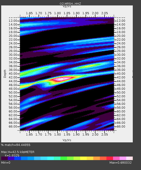
| Estimated Moho Depth: |
42.5 km |
| Estimated Crust Vp/Vs: |
1.83 |
| Assumed Crust Vp: |
6.483 km/s |
| Estimated Crust Vs: |
3.538 km/s |
| Estimated Crust Poisson's Ratio: |
0.29 |
|
| Radial Match: |
94.44855 % |
| Radial Bump: |
312 |
| Transverse Match: |
78.71393 % |
| Transverse Bump: |
400 |
| SOD ConfigId: |
21166931 |
| Insert Time: |
2020-06-17 07:47:36.692 +0000 |
| GWidth: |
2.5 |
| Max Bumps: |
400 |
| Tol: |
0.001 |
|

Signal To Noise
| Channel | StoN | STA | LTA |
| O2:MRSH: :HHZ:20200603T07:45:30.559998Z | 6.570409 | 5.7680717E-7 | 8.778863E-8 |
| O2:MRSH: :HHN:20200603T07:45:30.559998Z | 1.2496741 | 1.7838944E-7 | 1.4274876E-7 |
| O2:MRSH: :HHE:20200603T07:45:30.559998Z | 1.5757962 | 2.5043596E-7 | 1.5892662E-7 |
| Arrivals |
| Ps | 5.7 SECOND |
| PpPs | 18 SECOND |
| PsPs/PpSs | 24 SECOND |


