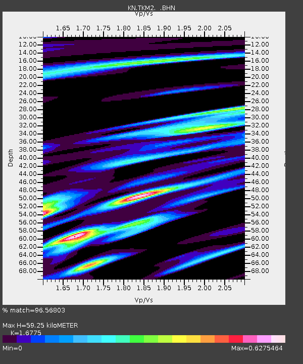
TKM2 KN.TKM2 - Earthquake Result Viewer
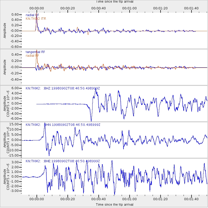
Earthquake location: Mindanao, Philippines
Earthquake latitude/longitude: 5.4/126.8
Earthquake time(UTC): 1998/09/02 (245) 08:37:29 GMT
Earthquake Depth: 50 km
Earthquake Magnitude: 6.6 MB, 6.7 MS, 6.8 UNKNOWN, 6.8 ME
Earthquake Catalog/Contributor: WHDF/NEIC
Network: KN Kyrgyz Seismic Telemetry Network
Station: TKM2 KN.TKM2
Lat/Lon: 42.92 N/75.60 E
Elevation: 2020 m
Distance: 58.5 deg
Az: 317.86 deg
Baz: 114.583 deg
Ray Param: 0.06267341
Estimated Moho Depth: 59.25 km
Estimated Crust Vp/Vs: 1.68
Assumed Crust Vp: 6.306 km/s
Estimated Crust Vs: 3.759 km/s
Estimated Crust Poisson's Ratio: 0.22
Radial Match: 96.56803 %
Radial Bump: 364
Transverse Match: 85.44403 %
Transverse Bump: 400
SOD ConfigId: 4480
Insert Time: 2010-03-08 20:48:02.379 +0000
GWidth: 2.5
Max Bumps: 400
Tol: 0.001

Signal To Noise

ChannelStoNSTALTA
KN:TKM2: :BHN:19980902T08:46:50.498999Z68.848063.0022964E-64.3607567E-8
KN:TKM2: :BHE:19980902T08:46:50.498999Z10.2469534.3035132E-74.1997982E-8
KN:TKM2: :BHZ:19980902T08:46:50.498999Z40.8399351.2394546E-63.0349085E-8
Arrivals
Ps6.7 SECOND
PpPs24 SECOND
PsPs/PpSs31 SECOND