You are here: Home > Network List > O2 - Oklahoma Consolidated Temporary Seismic Networks Stations List
> Station PERY Perry, Oklahoma, USA > Earthquake Result Viewer
PERY Perry, Oklahoma, USA - Earthquake Result Viewer
| Earthquake location: |
Northern Chile |
| Earthquake latitude/longitude: |
-23.4/-68.5 |
| Earthquake time(UTC): |
2020/06/03 (155) 07:35:34 GMT |
| Earthquake Depth: |
138 km |
| Earthquake Magnitude: |
6.8 Mi |
| Earthquake Catalog/Contributor: |
NEIC PDE/at |
|
| Network: |
O2 Oklahoma Consolidated Temporary Seismic Networks |
| Station: |
PERY Perry, Oklahoma, USA |
| Lat/Lon: |
36.26 N/97.24 W |
| Elevation: |
209 m |
|
| Distance: |
65.3 deg |
| Az: |
334.669 deg |
| Baz: |
150.9 deg |
| Ray Param: |
0.057998713 |
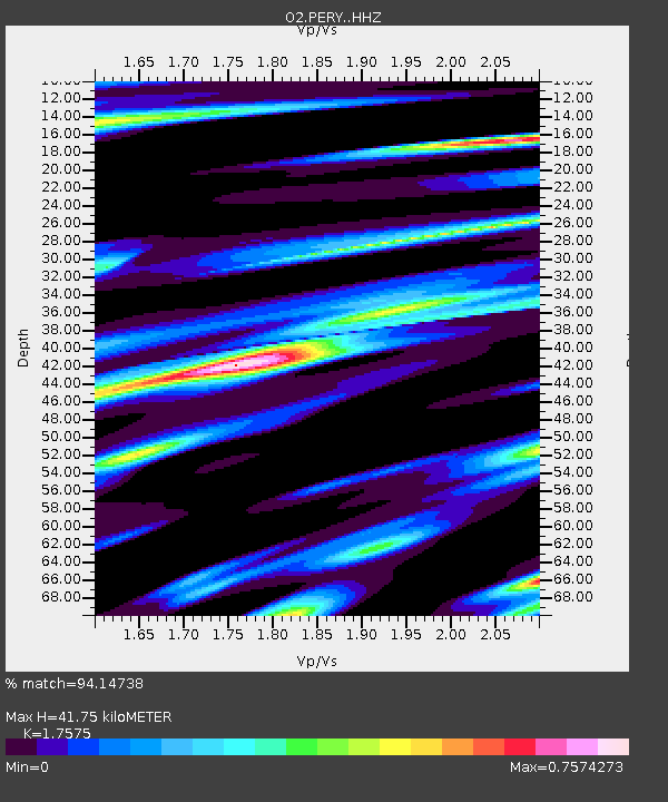
| Estimated Moho Depth: |
41.75 km |
| Estimated Crust Vp/Vs: |
1.76 |
| Assumed Crust Vp: |
6.483 km/s |
| Estimated Crust Vs: |
3.689 km/s |
| Estimated Crust Poisson's Ratio: |
0.26 |
|
| Radial Match: |
94.14738 % |
| Radial Bump: |
306 |
| Transverse Match: |
81.36954 % |
| Transverse Bump: |
400 |
| SOD ConfigId: |
21166931 |
| Insert Time: |
2020-06-17 07:47:39.612 +0000 |
| GWidth: |
2.5 |
| Max Bumps: |
400 |
| Tol: |
0.001 |
|

Signal To Noise
| Channel | StoN | STA | LTA |
| O2:PERY: :HHZ:20200603T07:45:30.099976Z | 3.2223155 | 2.9818216E-7 | 9.25366E-8 |
| O2:PERY: :HHN:20200603T07:45:30.099976Z | 1.4966326 | 1.6588166E-7 | 1.10836595E-7 |
| O2:PERY: :HHE:20200603T07:45:30.099976Z | 1.0636361 | 1.6614656E-7 | 1.5620621E-7 |
| Arrivals |
| Ps | 5.1 SECOND |
| PpPs | 17 SECOND |
| PsPs/PpSs | 22 SECOND |


