You are here: Home > Network List > O2 - Oklahoma Consolidated Temporary Seismic Networks Stations List
> Station SC12 Granite, Oklahoma, USA > Earthquake Result Viewer
SC12 Granite, Oklahoma, USA - Earthquake Result Viewer
| Earthquake location: |
Northern Chile |
| Earthquake latitude/longitude: |
-23.4/-68.5 |
| Earthquake time(UTC): |
2020/06/03 (155) 07:35:34 GMT |
| Earthquake Depth: |
138 km |
| Earthquake Magnitude: |
6.8 Mi |
| Earthquake Catalog/Contributor: |
NEIC PDE/at |
|
| Network: |
O2 Oklahoma Consolidated Temporary Seismic Networks |
| Station: |
SC12 Granite, Oklahoma, USA |
| Lat/Lon: |
34.92 N/99.35 W |
| Elevation: |
472 m |
|
| Distance: |
65.0 deg |
| Az: |
332.283 deg |
| Baz: |
148.667 deg |
| Ray Param: |
0.058183514 |
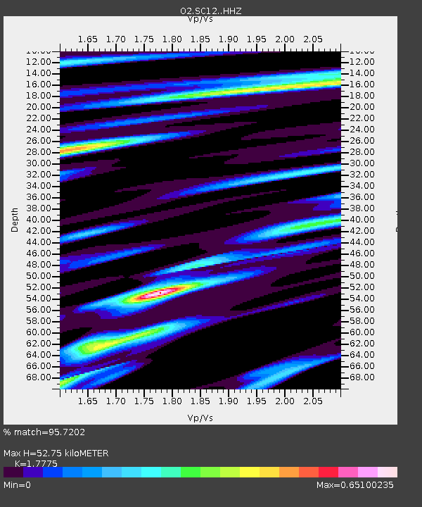
| Estimated Moho Depth: |
52.75 km |
| Estimated Crust Vp/Vs: |
1.78 |
| Assumed Crust Vp: |
6.315 km/s |
| Estimated Crust Vs: |
3.553 km/s |
| Estimated Crust Poisson's Ratio: |
0.27 |
|
| Radial Match: |
95.7202 % |
| Radial Bump: |
283 |
| Transverse Match: |
78.794914 % |
| Transverse Bump: |
400 |
| SOD ConfigId: |
21166931 |
| Insert Time: |
2020-06-17 07:48:07.002 +0000 |
| GWidth: |
2.5 |
| Max Bumps: |
400 |
| Tol: |
0.001 |
|

Signal To Noise
| Channel | StoN | STA | LTA |
| O2:SC12: :HHZ:20200603T07:45:28.27002Z | 10.008429 | 5.80543E-7 | 5.8005405E-8 |
| O2:SC12: :HHN:20200603T07:45:28.27002Z | 2.4792309 | 2.2888098E-7 | 9.231934E-8 |
| O2:SC12: :HHE:20200603T07:45:28.27002Z | 2.102956 | 1.4837153E-7 | 7.0553796E-8 |
| Arrivals |
| Ps | 6.8 SECOND |
| PpPs | 22 SECOND |
| PsPs/PpSs | 29 SECOND |


