You are here: Home > Network List > TX - Texas Seismological Network Stations List
> Station WTFS Witchita Falls > Earthquake Result Viewer
WTFS Witchita Falls - Earthquake Result Viewer

| Earthquake location: |
Northern Chile |
| Earthquake latitude/longitude: |
-23.4/-68.5 |
| Earthquake time(UTC): |
2020/06/03 (155) 07:35:34 GMT |
| Earthquake Depth: |
138 km |
| Earthquake Magnitude: |
6.8 Mi |
| Earthquake Catalog/Contributor: |
NEIC PDE/at |
|
| Network: |
TX Texas Seismological Network |
| Station: |
WTFS Witchita Falls |
| Lat/Lon: |
33.77 N/98.46 W |
| Elevation: |
277 m |
|
| Distance: |
63.6 deg |
| Az: |
332.323 deg |
| Baz: |
149.185 deg |
| Ray Param: |
0.059068963 |
| Estimated Moho Depth: |
11.25 km |
| Estimated Crust Vp/Vs: |
1.62 |
| Assumed Crust Vp: |
6.426 km/s |
| Estimated Crust Vs: |
3.973 km/s |
| Estimated Crust Poisson's Ratio: |
0.19 |
|
| Radial Match: |
96.70583 % |
| Radial Bump: |
283 |
| Transverse Match: |
86.966225 % |
| Transverse Bump: |
386 |
| SOD ConfigId: |
21166931 |
| Insert Time: |
2020-06-17 07:51:38.569 +0000 |
| GWidth: |
2.5 |
| Max Bumps: |
400 |
| Tol: |
0.001 |
|
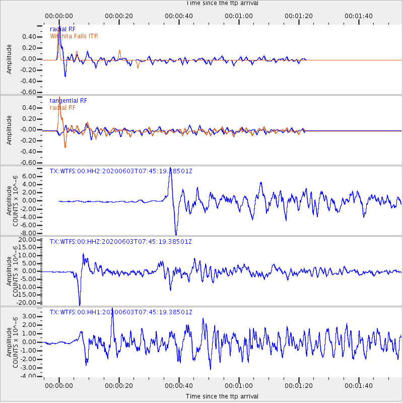
Signal To Noise
| Channel | StoN | STA | LTA |
| TX:WTFS:00:HHZ:20200603T07:45:19.38501Z | 2.3980381 | 1.8330854E-7 | 7.644105E-8 |
| TX:WTFS:00:HH1:20200603T07:45:19.38501Z | 0.8762502 | 9.513354E-8 | 1.0856892E-7 |
| TX:WTFS:00:HH2:20200603T07:45:19.38501Z | 1.758886 | 1.5139224E-7 | 8.60728E-8 |
| Arrivals |
| Ps | 1.1 SECOND |
| PpPs | 4.4 SECOND |
| PsPs/PpSs | 5.5 SECOND |


