You are here: Home > Network List > US - United States National Seismic Network Stations List
> Station MIAR Mount Ida, Arkansas, USA > Earthquake Result Viewer
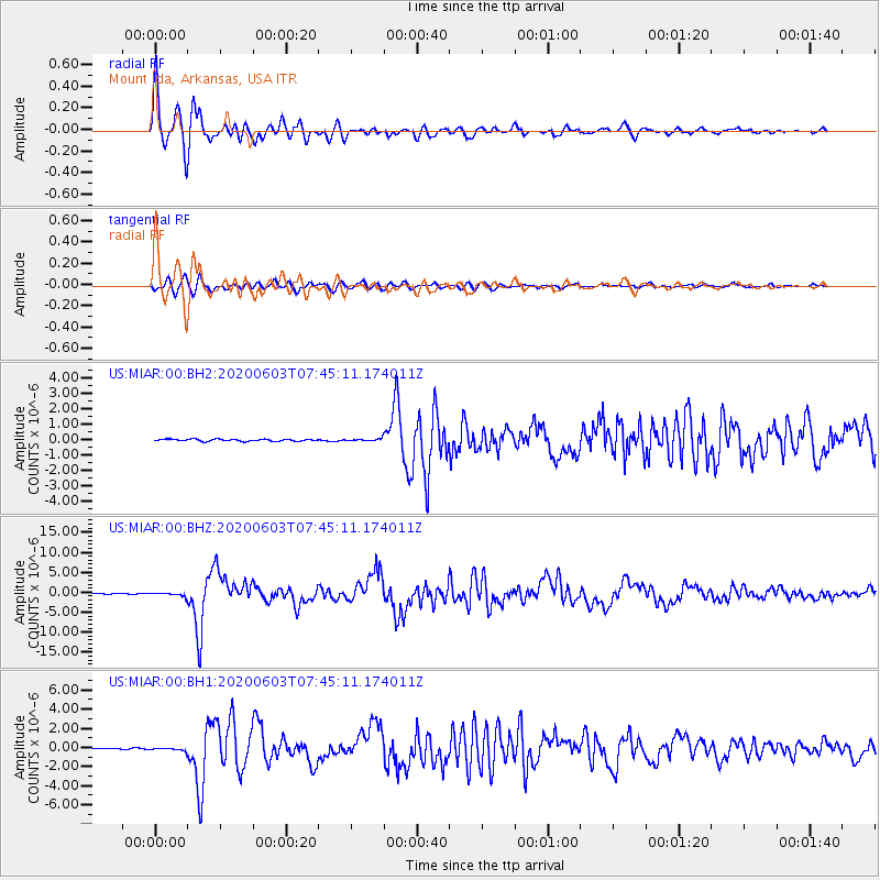
MIAR Mount Ida, Arkansas, USA - Earthquake Result Viewer
| Earthquake location: |
Northern Chile |
| Earthquake latitude/longitude: |
-23.4/-68.5 |
| Earthquake time(UTC): |
2020/06/03 (155) 07:35:34 GMT |
| Earthquake Depth: |
138 km |
| Earthquake Magnitude: |
6.8 Mi |
| Earthquake Catalog/Contributor: |
NEIC PDE/at |
|
| Network: |
US United States National Seismic Network |
| Station: |
MIAR Mount Ida, Arkansas, USA |
| Lat/Lon: |
34.55 N/93.58 W |
| Elevation: |
207 m |
|
| Distance: |
62.4 deg |
| Az: |
336.738 deg |
| Baz: |
153.925 deg |
| Ray Param: |
0.05986825 |
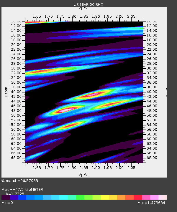
| Estimated Moho Depth: |
47.5 km |
| Estimated Crust Vp/Vs: |
1.77 |
| Assumed Crust Vp: |
6.498 km/s |
| Estimated Crust Vs: |
3.666 km/s |
| Estimated Crust Poisson's Ratio: |
0.27 |
|
| Radial Match: |
96.57085 % |
| Radial Bump: |
400 |
| Transverse Match: |
89.43126 % |
| Transverse Bump: |
400 |
| SOD ConfigId: |
21166931 |
| Insert Time: |
2020-06-17 07:52:25.324 +0000 |
| GWidth: |
2.5 |
| Max Bumps: |
400 |
| Tol: |
0.001 |
|
Signal To Noise
| Channel | StoN | STA | LTA |
| US:MIAR:00:BHZ:20200603T07:45:11.174011Z | 7.806217 | 4.2956142E-7 | 5.5028117E-8 |
| US:MIAR:00:BH1:20200603T07:45:11.174011Z | 2.2993393 | 1.3477795E-7 | 5.8615946E-8 |
| US:MIAR:00:BH2:20200603T07:45:11.174011Z | 1.031436 | 7.001211E-8 | 6.78783E-8 |
| Arrivals |
| Ps | 5.9 SECOND |
| PpPs | 19 SECOND |
| PsPs/PpSs | 25 SECOND |


