You are here: Home > Network List > UU - University of Utah Regional Network Stations List
> Station HMU Henry Mountain, UT, USA > Earthquake Result Viewer
HMU Henry Mountain, UT, USA - Earthquake Result Viewer
| Earthquake location: |
Northern Chile |
| Earthquake latitude/longitude: |
-23.4/-68.5 |
| Earthquake time(UTC): |
2020/06/03 (155) 07:35:34 GMT |
| Earthquake Depth: |
138 km |
| Earthquake Magnitude: |
6.8 Mi |
| Earthquake Catalog/Contributor: |
NEIC PDE/at |
|
| Network: |
UU University of Utah Regional Network |
| Station: |
HMU Henry Mountain, UT, USA |
| Lat/Lon: |
37.94 N/110.74 W |
| Elevation: |
2430 m |
|
| Distance: |
72.8 deg |
| Az: |
326.188 deg |
| Baz: |
139.715 deg |
| Ray Param: |
0.053086266 |
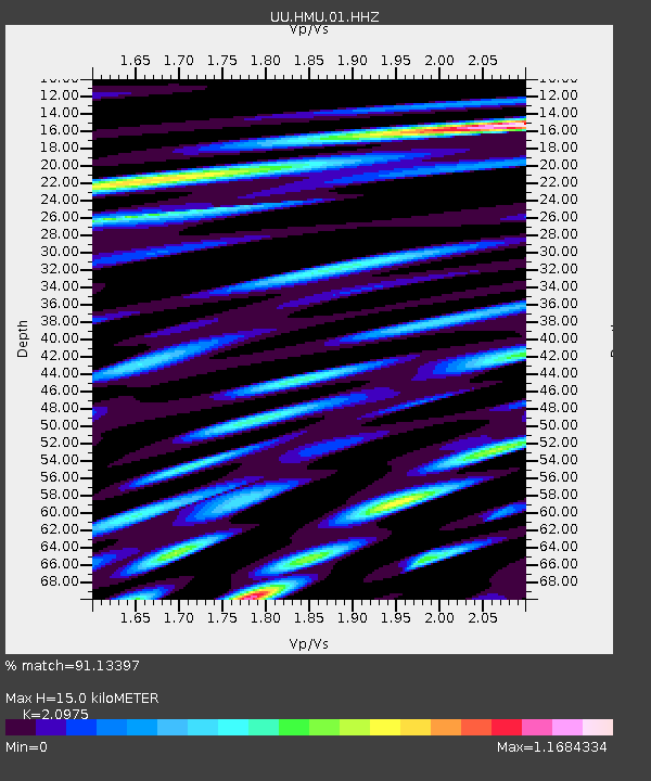
| Estimated Moho Depth: |
15.0 km |
| Estimated Crust Vp/Vs: |
2.10 |
| Assumed Crust Vp: |
6.247 km/s |
| Estimated Crust Vs: |
2.978 km/s |
| Estimated Crust Poisson's Ratio: |
0.35 |
|
| Radial Match: |
91.13397 % |
| Radial Bump: |
400 |
| Transverse Match: |
82.27391 % |
| Transverse Bump: |
400 |
| SOD ConfigId: |
21166931 |
| Insert Time: |
2020-06-17 07:52:44.990 +0000 |
| GWidth: |
2.5 |
| Max Bumps: |
400 |
| Tol: |
0.001 |
|

Signal To Noise
| Channel | StoN | STA | LTA |
| UU:HMU:01:HHZ:20200603T07:46:16.41803Z | 1.083412 | 2.9462388E-9 | 2.7194074E-9 |
| UU:HMU:01:HHN:20200603T07:46:16.41803Z | 0.375754 | 1.5861913E-9 | 4.221356E-9 |
| UU:HMU:01:HHE:20200603T07:46:16.41803Z | 1.4173557 | 3.774568E-9 | 2.6631057E-9 |
| Arrivals |
| Ps | 2.7 SECOND |
| PpPs | 7.2 SECOND |
| PsPs/PpSs | 9.9 SECOND |


