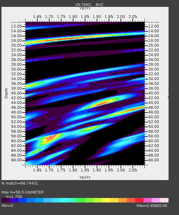
TKM2 KN.TKM2 - Earthquake Result Viewer
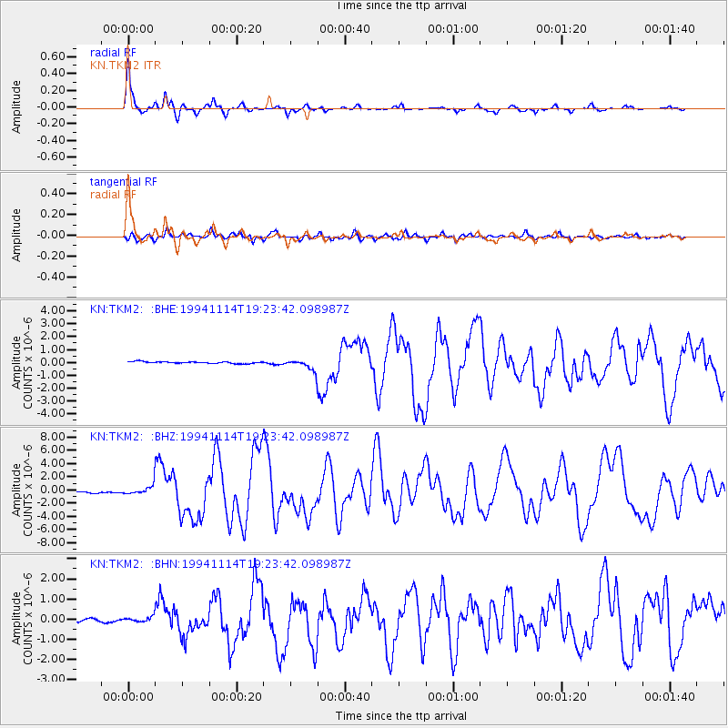
Earthquake location: Mindoro, Philippines
Earthquake latitude/longitude: 13.5/121.1
Earthquake time(UTC): 1994/11/14 (318) 19:15:30 GMT
Earthquake Depth: 33 km
Earthquake Magnitude: 6.1 MB, 7.1 MS, 7.1 UNKNOWN, 7.1 MW
Earthquake Catalog/Contributor: WHDF/NEIC
Network: KN Kyrgyz Seismic Telemetry Network
Station: TKM2 KN.TKM2
Lat/Lon: 42.92 N/75.60 E
Elevation: 2020 m
Distance: 48.8 deg
Az: 315.881 deg
Baz: 112.82 deg
Ray Param: 0.06904986
Estimated Moho Depth: 58.0 km
Estimated Crust Vp/Vs: 1.71
Assumed Crust Vp: 6.306 km/s
Estimated Crust Vs: 3.699 km/s
Estimated Crust Poisson's Ratio: 0.24
Radial Match: 96.74431 %
Radial Bump: 283
Transverse Match: 89.6037 %
Transverse Bump: 400
SOD ConfigId: 4480
Insert Time: 2010-03-08 20:48:36.448 +0000
GWidth: 2.5
Max Bumps: 400
Tol: 0.001

Signal To Noise

ChannelStoNSTALTA
KN:TKM2: :BHZ:19941114T19:23:42.098987Z7.01497556.6970046E-79.546725E-8
KN:TKM2: :BHN:19941114T19:23:42.098987Z1.70558741.2646689E-77.414858E-8
KN:TKM2: :BHE:19941114T19:23:42.098987Z6.1948784.2931282E-76.930125E-8
Arrivals
Ps6.9 SECOND
PpPs23 SECOND
PsPs/PpSs30 SECOND