You are here: Home > Network List > US - United States National Seismic Network Stations List
> Station CBKS Cedar Bluff, Kansas, USA > Earthquake Result Viewer
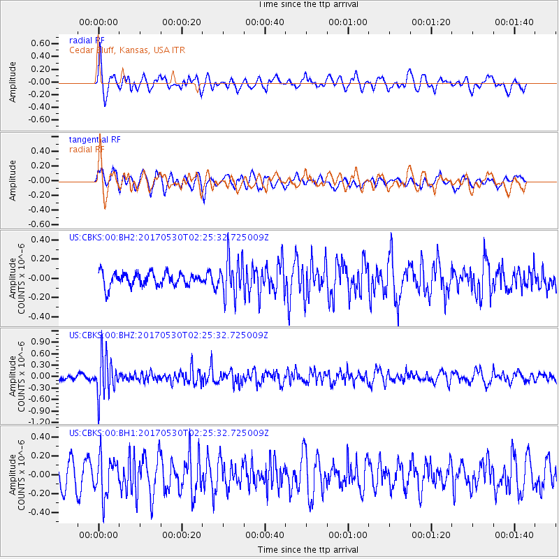
CBKS Cedar Bluff, Kansas, USA - Earthquake Result Viewer
*The percent match for this event was below the threshold and hence no stack was calculated.
| Earthquake location: |
Kenai Peninsula, Alaska |
| Earthquake latitude/longitude: |
60.8/-151.8 |
| Earthquake time(UTC): |
2017/05/30 (150) 02:18:45 GMT |
| Earthquake Depth: |
78 km |
| Earthquake Magnitude: |
5.2 Mww |
| Earthquake Catalog/Contributor: |
NEIC PDE/ak |
|
| Network: |
US United States National Seismic Network |
| Station: |
CBKS Cedar Bluff, Kansas, USA |
| Lat/Lon: |
38.81 N/99.74 W |
| Elevation: |
677 m |
|
| Distance: |
38.8 deg |
| Az: |
100.367 deg |
| Baz: |
321.925 deg |
| Ray Param: |
$rayparam |
*The percent match for this event was below the threshold and hence was not used in the summary stack. |
|
| Radial Match: |
62.83151 % |
| Radial Bump: |
392 |
| Transverse Match: |
49.211525 % |
| Transverse Bump: |
371 |
| SOD ConfigId: |
2140511 |
| Insert Time: |
2017-06-20 22:33:43.954 +0000 |
| GWidth: |
2.5 |
| Max Bumps: |
400 |
| Tol: |
0.001 |
|
Signal To Noise
| Channel | StoN | STA | LTA |
| US:CBKS:00:BHZ:20170530T02:25:32.725009Z | 5.95377 | 5.10024E-7 | 8.566404E-8 |
| US:CBKS:00:BH1:20170530T02:25:32.725009Z | 1.6330714 | 2.0850347E-7 | 1.2767566E-7 |
| US:CBKS:00:BH2:20170530T02:25:32.725009Z | 2.9079263 | 1.9878209E-7 | 6.83587E-8 |
| Arrivals |
| Ps | |
| PpPs | |
| PsPs/PpSs | |


