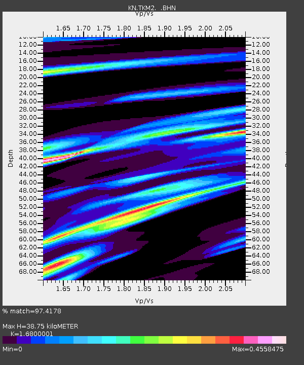
TKM2 KN.TKM2 - Earthquake Result Viewer
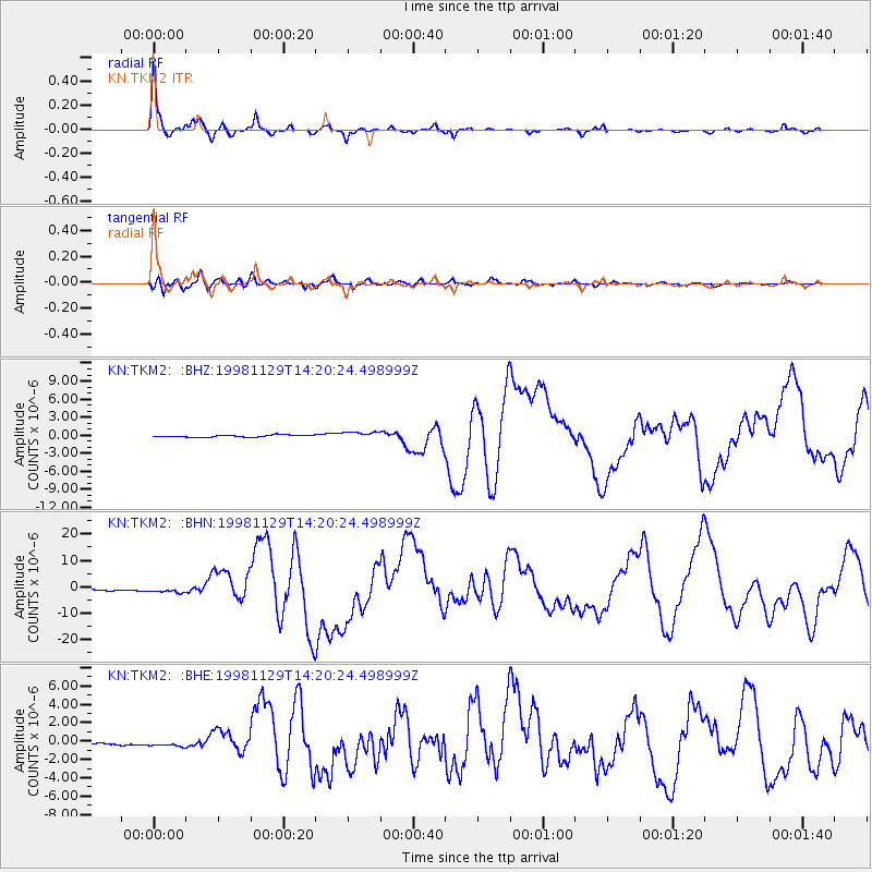
Earthquake location: Ceram Sea
Earthquake latitude/longitude: -2.1/124.9
Earthquake time(UTC): 1998/11/29 (333) 14:10:31 GMT
Earthquake Depth: 33 km
Earthquake Magnitude: 6.5 MB, 7.7 MS, 8.1 UNKNOWN, 7.8 MW
Earthquake Catalog/Contributor: WHDF/NEIC
Network: KN Kyrgyz Seismic Telemetry Network
Station: TKM2 KN.TKM2
Lat/Lon: 42.92 N/75.60 E
Elevation: 2020 m
Distance: 63.0 deg
Az: 321.309 deg
Baz: 121.739 deg
Ray Param: 0.05982387
Estimated Moho Depth: 38.75 km
Estimated Crust Vp/Vs: 1.68
Assumed Crust Vp: 6.306 km/s
Estimated Crust Vs: 3.754 km/s
Estimated Crust Poisson's Ratio: 0.23
Radial Match: 97.4178 %
Radial Bump: 273
Transverse Match: 85.71046 %
Transverse Bump: 400
SOD ConfigId: 4480
Insert Time: 2010-03-08 20:49:17.395 +0000
GWidth: 2.5
Max Bumps: 400
Tol: 0.001

Signal To Noise

ChannelStoNSTALTA
KN:TKM2: :BHN:19981129T14:20:24.498999Z3.15652681.1531636E-63.653267E-7
KN:TKM2: :BHE:19981129T14:20:24.498999Z2.74271563.8739358E-71.4124454E-7
KN:TKM2: :BHZ:19981129T14:20:24.498999Z3.18643935.8006964E-71.8204321E-7
Arrivals
Ps4.4 SECOND
PpPs16 SECOND
PsPs/PpSs20 SECOND