You are here: Home > Network List > TS - TERRAscope (Southern California Seismic Network) Stations List
> Station SVD Seven Oaks Dam, California, USA > Earthquake Result Viewer
SVD Seven Oaks Dam, California, USA - Earthquake Result Viewer

| Earthquake location: |
Fiji Islands Region |
| Earthquake latitude/longitude: |
-20.9/-179.2 |
| Earthquake time(UTC): |
1995/01/17 (017) 16:54:12 GMT |
| Earthquake Depth: |
637 km |
| Earthquake Magnitude: |
6.0 MB, 6.2 UNKNOWN, 6.4 MW |
| Earthquake Catalog/Contributor: |
WHDF/NEIC |
|
| Network: |
TS TERRAscope (Southern California Seismic Network) |
| Station: |
SVD Seven Oaks Dam, California, USA |
| Lat/Lon: |
34.10 N/117.10 W |
| Elevation: |
600 m |
|
| Distance: |
80.5 deg |
| Az: |
48.048 deg |
| Baz: |
236.95 deg |
| Ray Param: |
0.046241257 |
| Estimated Moho Depth: |
36.75 km |
| Estimated Crust Vp/Vs: |
1.62 |
| Assumed Crust Vp: |
6.276 km/s |
| Estimated Crust Vs: |
3.874 km/s |
| Estimated Crust Poisson's Ratio: |
0.19 |
|
| Radial Match: |
82.74678 % |
| Radial Bump: |
400 |
| Transverse Match: |
72.741425 % |
| Transverse Bump: |
400 |
| SOD ConfigId: |
6273 |
| Insert Time: |
2010-02-26 14:52:47.970 +0000 |
| GWidth: |
2.5 |
| Max Bumps: |
400 |
| Tol: |
0.001 |
|
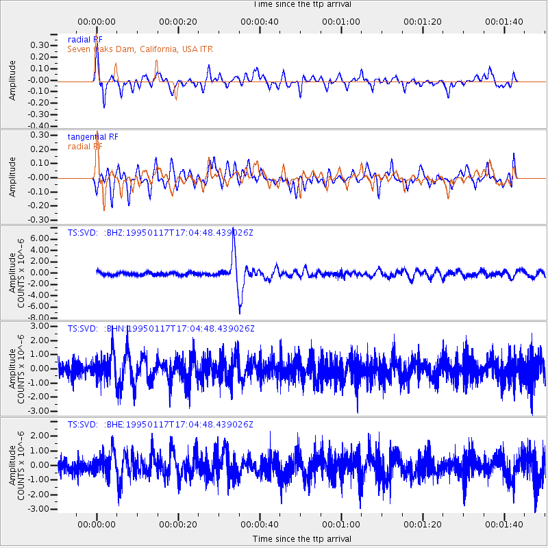
Signal To Noise
| Channel | StoN | STA | LTA |
| TS:SVD: :BHN:19950117T17:04:48.439026Z | 1.5580094 | 9.847439E-7 | 6.320526E-7 |
| TS:SVD: :BHE:19950117T17:04:48.439026Z | 1.6421387 | 8.3297726E-7 | 5.0725146E-7 |
| TS:SVD: :BHZ:19950117T17:04:48.439026Z | 9.900351 | 2.6568212E-6 | 2.6835627E-7 |
| Arrivals |
| Ps | 3.7 SECOND |
| PpPs | 15 SECOND |
| PsPs/PpSs | 19 SECOND |


