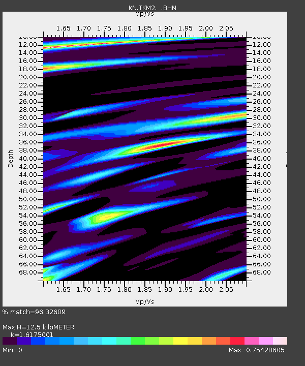
TKM2 KN.TKM2 - Earthquake Result Viewer
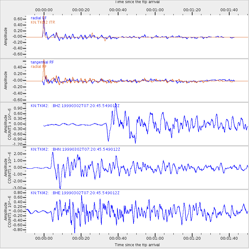
Earthquake location: Near East Coast Of Honshu, Japan
Earthquake latitude/longitude: 35.6/141.8
Earthquake time(UTC): 1999/03/02 (061) 07:12:20 GMT
Earthquake Depth: 33 km
Earthquake Magnitude: 5.6 MS, 5.4 MB, 6.1 MW, 6.0 MW
Earthquake Catalog/Contributor: WHDF/NEIC
Network: KN Kyrgyz Seismic Telemetry Network
Station: TKM2 KN.TKM2
Lat/Lon: 42.92 N/75.60 E
Elevation: 2020 m
Distance: 50.6 deg
Az: 299.553 deg
Baz: 74.834 deg
Ray Param: 0.06790565
Estimated Moho Depth: 12.5 km
Estimated Crust Vp/Vs: 1.62
Assumed Crust Vp: 6.306 km/s
Estimated Crust Vs: 3.899 km/s
Estimated Crust Poisson's Ratio: 0.19
Radial Match: 96.32609 %
Radial Bump: 319
Transverse Match: 83.940765 %
Transverse Bump: 400
SOD ConfigId: 4480
Insert Time: 2010-03-08 20:50:23.833 +0000
GWidth: 2.5
Max Bumps: 400
Tol: 0.001

Signal To Noise

ChannelStoNSTALTA
KN:TKM2: :BHN:19990302T07:20:45.549012Z14.5854537.028945E-74.8191474E-8
KN:TKM2: :BHE:19990302T07:20:45.549012Z2.8109481.201088E-74.272893E-8
KN:TKM2: :BHZ:19990302T07:20:45.549012Z7.6166212.739405E-73.5966142E-8
Arrivals
Ps1.3 SECOND
PpPs4.9 SECOND
PsPs/PpSs6.2 SECOND