You are here: Home > Network List > TA - USArray Transportable Network (new EarthScope stations) Stations List
> Station I17K Unalakleet, AK, USA > Earthquake Result Viewer
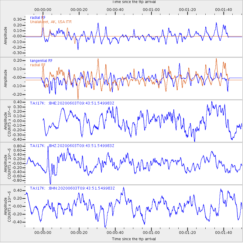
I17K Unalakleet, AK, USA - Earthquake Result Viewer
*The percent match for this event was below the threshold and hence no stack was calculated.
| Earthquake location: |
South Of Fiji Islands |
| Earthquake latitude/longitude: |
-24.7/-176.6 |
| Earthquake time(UTC): |
2020/06/03 (155) 09:31:36 GMT |
| Earthquake Depth: |
88 km |
| Earthquake Magnitude: |
5.9 mww |
| Earthquake Catalog/Contributor: |
NEIC PDE/us |
|
| Network: |
TA USArray Transportable Network (new EarthScope stations) |
| Station: |
I17K Unalakleet, AK, USA |
| Lat/Lon: |
63.89 N/160.70 W |
| Elevation: |
105 m |
|
| Distance: |
89.2 deg |
| Az: |
6.963 deg |
| Baz: |
194.428 deg |
| Ray Param: |
$rayparam |
*The percent match for this event was below the threshold and hence was not used in the summary stack. |
|
| Radial Match: |
58.810715 % |
| Radial Bump: |
398 |
| Transverse Match: |
63.137413 % |
| Transverse Bump: |
351 |
| SOD ConfigId: |
21166931 |
| Insert Time: |
2020-06-17 09:46:34.759 +0000 |
| GWidth: |
2.5 |
| Max Bumps: |
400 |
| Tol: |
0.001 |
|
Signal To Noise
| Channel | StoN | STA | LTA |
| TA:I17K: :BHZ:20200603T09:43:51.549983Z | 3.7300785 | 4.686209E-7 | 1.25633E-7 |
| TA:I17K: :BHN:20200603T09:43:51.549983Z | 0.5928262 | 1.2360346E-7 | 2.0849865E-7 |
| TA:I17K: :BHE:20200603T09:43:51.549983Z | 0.7678016 | 1.1900673E-7 | 1.5499673E-7 |
| Arrivals |
| Ps | |
| PpPs | |
| PsPs/PpSs | |


