You are here: Home > Network List > TA - USArray Transportable Network (new EarthScope stations) Stations List
> Station L15K Ungalak Mountain, AK, USA > Earthquake Result Viewer
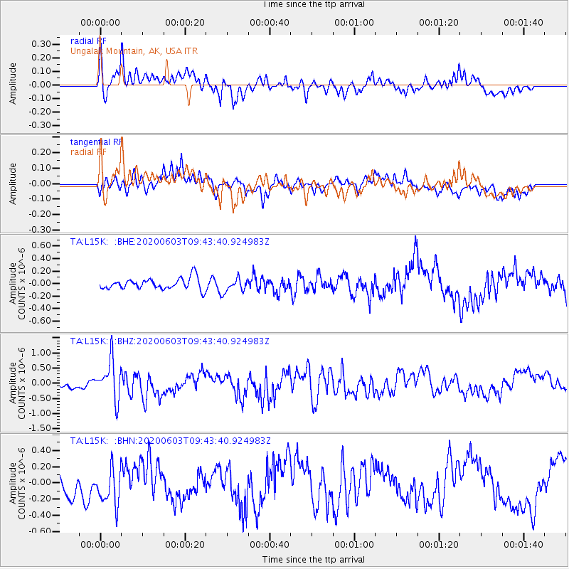
L15K Ungalak Mountain, AK, USA - Earthquake Result Viewer
*The percent match for this event was below the threshold and hence no stack was calculated.
| Earthquake location: |
South Of Fiji Islands |
| Earthquake latitude/longitude: |
-24.7/-176.6 |
| Earthquake time(UTC): |
2020/06/03 (155) 09:31:36 GMT |
| Earthquake Depth: |
88 km |
| Earthquake Magnitude: |
5.9 mww |
| Earthquake Catalog/Contributor: |
NEIC PDE/us |
|
| Network: |
TA USArray Transportable Network (new EarthScope stations) |
| Station: |
L15K Ungalak Mountain, AK, USA |
| Lat/Lon: |
61.68 N/161.49 W |
| Elevation: |
219 m |
|
| Distance: |
86.9 deg |
| Az: |
7.149 deg |
| Baz: |
193.731 deg |
| Ray Param: |
$rayparam |
*The percent match for this event was below the threshold and hence was not used in the summary stack. |
|
| Radial Match: |
67.42986 % |
| Radial Bump: |
400 |
| Transverse Match: |
66.920746 % |
| Transverse Bump: |
400 |
| SOD ConfigId: |
21166931 |
| Insert Time: |
2020-06-17 09:46:46.734 +0000 |
| GWidth: |
2.5 |
| Max Bumps: |
400 |
| Tol: |
0.001 |
|
Signal To Noise
| Channel | StoN | STA | LTA |
| TA:L15K: :BHZ:20200603T09:43:40.924983Z | 6.103189 | 6.6112756E-7 | 1.0832493E-7 |
| TA:L15K: :BHN:20200603T09:43:40.924983Z | 1.2843133 | 2.3251197E-7 | 1.8103992E-7 |
| TA:L15K: :BHE:20200603T09:43:40.924983Z | 1.1334372 | 1.0209807E-7 | 9.007829E-8 |
| Arrivals |
| Ps | |
| PpPs | |
| PsPs/PpSs | |


