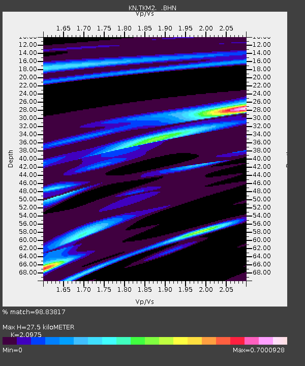
TKM2 KN.TKM2 - Earthquake Result Viewer
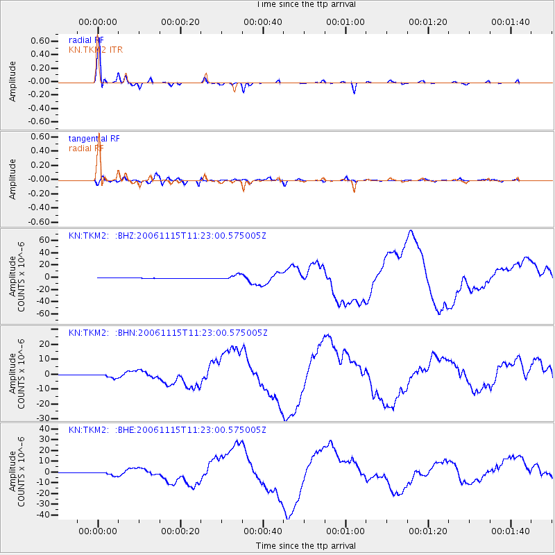
Earthquake location: Kuril Islands
Earthquake latitude/longitude: 46.6/153.3
Earthquake time(UTC): 2006/11/15 (319) 11:14:13 GMT
Earthquake Depth: 10 km
Earthquake Magnitude: 6.5 MB, 7.8 MS, 8.3 MW, 7.9 MW
Earthquake Catalog/Contributor: WHDF/NEIC
Network: KN Kyrgyz Seismic Telemetry Network
Station: TKM2 KN.TKM2
Lat/Lon: 42.92 N/75.60 E
Elevation: 2020 m
Distance: 53.2 deg
Az: 296.278 deg
Baz: 57.329 deg
Ray Param: 0.06628496
Estimated Moho Depth: 27.5 km
Estimated Crust Vp/Vs: 2.10
Assumed Crust Vp: 6.306 km/s
Estimated Crust Vs: 3.006 km/s
Estimated Crust Poisson's Ratio: 0.35
Radial Match: 98.83817 %
Radial Bump: 235
Transverse Match: 91.419426 %
Transverse Bump: 400
SOD ConfigId: 2564
Insert Time: 2010-03-08 20:50:34.456 +0000
GWidth: 2.5
Max Bumps: 400
Tol: 0.001

Signal To Noise

ChannelStoNSTALTA
KN:TKM2: :BHN:20061115T11:23:00.575005Z6.2633091.2423296E-61.9835036E-7
KN:TKM2: :BHE:20061115T11:23:00.575005Z5.15244531.6166144E-63.1375674E-7
KN:TKM2: :BHZ:20061115T11:23:00.575005Z10.30958753.9754595E-63.85608E-7
Arrivals
Ps5.0 SECOND
PpPs13 SECOND
PsPs/PpSs18 SECOND