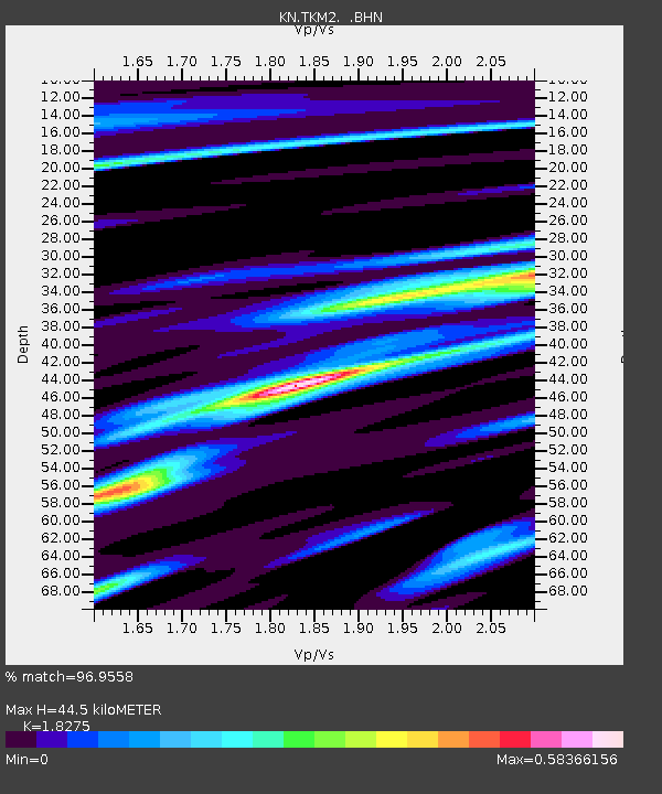
TKM2 KN.TKM2 - Earthquake Result Viewer
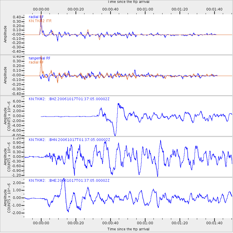
Earthquake location: New Britain Region, P.N.G.
Earthquake latitude/longitude: -5.9/151.0
Earthquake time(UTC): 2006/10/17 (290) 01:25:12 GMT
Earthquake Depth: 32 km
Earthquake Magnitude: 6.4 MB, 6.9 MS, 6.7 MW, 6.6 MW
Earthquake Catalog/Contributor: WHDF/NEIC
Network: KN Kyrgyz Seismic Telemetry Network
Station: TKM2 KN.TKM2
Lat/Lon: 42.92 N/75.60 E
Elevation: 2020 m
Distance: 83.4 deg
Az: 314.309 deg
Baz: 104.284 deg
Ray Param: 0.04618882
Estimated Moho Depth: 44.5 km
Estimated Crust Vp/Vs: 1.83
Assumed Crust Vp: 6.306 km/s
Estimated Crust Vs: 3.451 km/s
Estimated Crust Poisson's Ratio: 0.29
Radial Match: 96.9558 %
Radial Bump: 332
Transverse Match: 87.47581 %
Transverse Bump: 400
SOD ConfigId: 2665
Insert Time: 2010-03-08 20:50:51.979 +0000
GWidth: 2.5
Max Bumps: 400
Tol: 0.001

Signal To Noise

ChannelStoNSTALTA
KN:TKM2: :BHN:20061017T01:37:05.00002Z1.3971959.689985E-86.9353135E-8
KN:TKM2: :BHE:20061017T01:37:05.00002Z7.415564.0684048E-75.4863087E-8
KN:TKM2: :BHZ:20061017T01:37:05.00002Z24.1446481.3527805E-65.6028174E-8
Arrivals
Ps6.0 SECOND
PpPs19 SECOND
PsPs/PpSs25 SECOND