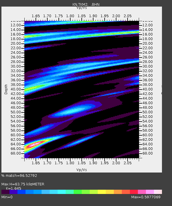
TKM2 KN.TKM2 - Earthquake Result Viewer
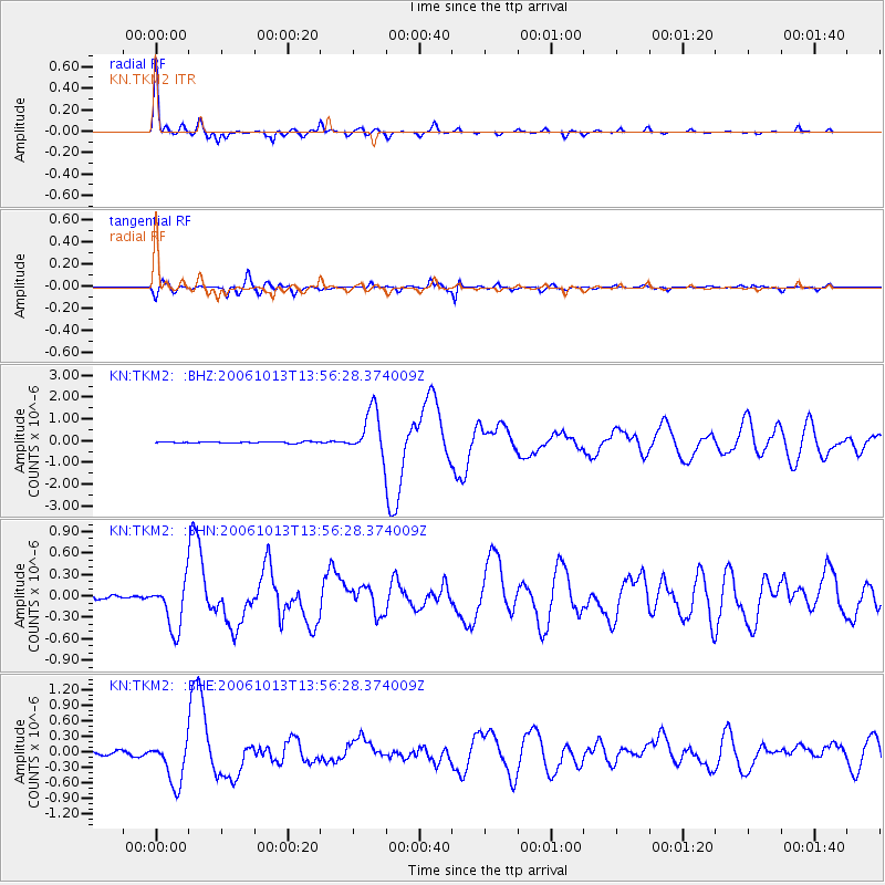
Earthquake location: Kuril Islands
Earthquake latitude/longitude: 46.3/153.3
Earthquake time(UTC): 2006/10/13 (286) 13:47:39 GMT
Earthquake Depth: 8.0 km
Earthquake Magnitude: 5.5 MB, 5.8 MS, 6.3 MW, 5.8 MW
Earthquake Catalog/Contributor: WHDF/NEIC
Network: KN Kyrgyz Seismic Telemetry Network
Station: TKM2 KN.TKM2
Lat/Lon: 42.92 N/75.60 E
Elevation: 2020 m
Distance: 53.3 deg
Az: 296.512 deg
Baz: 57.705 deg
Ray Param: 0.0661832
Estimated Moho Depth: 63.75 km
Estimated Crust Vp/Vs: 1.64
Assumed Crust Vp: 6.306 km/s
Estimated Crust Vs: 3.833 km/s
Estimated Crust Poisson's Ratio: 0.21
Radial Match: 96.52792 %
Radial Bump: 337
Transverse Match: 90.44882 %
Transverse Bump: 400
SOD ConfigId: 2665
Insert Time: 2010-03-08 20:50:53.612 +0000
GWidth: 2.5
Max Bumps: 400
Tol: 0.001

Signal To Noise

ChannelStoNSTALTA
KN:TKM2: :BHN:20061013T13:56:28.374009Z13.7218823.4155892E-72.489155E-8
KN:TKM2: :BHE:20061013T13:56:28.374009Z13.3683584.2787715E-73.200671E-8
KN:TKM2: :BHZ:20061013T13:56:28.374009Z33.633021.0542514E-63.1345728E-8
Arrivals
Ps6.9 SECOND
PpPs25 SECOND
PsPs/PpSs32 SECOND