You are here: Home > Network List > AV - Alaska Volcano Observatory Stations List
> Station AMKA Regional Station, Amchitka Island, Alaska > Earthquake Result Viewer
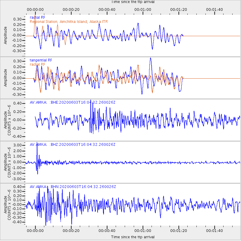
AMKA Regional Station, Amchitka Island, Alaska - Earthquake Result Viewer
*The percent match for this event was below the threshold and hence no stack was calculated.
| Earthquake location: |
Bali Sea |
| Earthquake latitude/longitude: |
-7.0/116.9 |
| Earthquake time(UTC): |
2020/06/03 (155) 15:54:04 GMT |
| Earthquake Depth: |
640 km |
| Earthquake Magnitude: |
5.7 Mww |
| Earthquake Catalog/Contributor: |
NEIC PDE/us |
|
| Network: |
AV Alaska Volcano Observatory |
| Station: |
AMKA Regional Station, Amchitka Island, Alaska |
| Lat/Lon: |
51.38 N/179.30 E |
| Elevation: |
116 m |
|
| Distance: |
78.8 deg |
| Az: |
34.482 deg |
| Baz: |
243.721 deg |
| Ray Param: |
$rayparam |
*The percent match for this event was below the threshold and hence was not used in the summary stack. |
|
| Radial Match: |
61.418053 % |
| Radial Bump: |
400 |
| Transverse Match: |
60.361916 % |
| Transverse Bump: |
400 |
| SOD ConfigId: |
21166931 |
| Insert Time: |
2020-06-17 15:55:31.653 +0000 |
| GWidth: |
2.5 |
| Max Bumps: |
400 |
| Tol: |
0.001 |
|
Signal To Noise
| Channel | StoN | STA | LTA |
| AV:AMKA: :BHZ:20200603T16:04:32.260026Z | 10.568707 | 8.513724E-7 | 8.0555964E-8 |
| AV:AMKA: :BHN:20200603T16:04:32.260026Z | 2.1655655 | 1.3682572E-7 | 6.318244E-8 |
| AV:AMKA: :BHE:20200603T16:04:32.260026Z | 2.030357 | 1.7089752E-7 | 8.417117E-8 |
| Arrivals |
| Ps | |
| PpPs | |
| PsPs/PpSs | |


