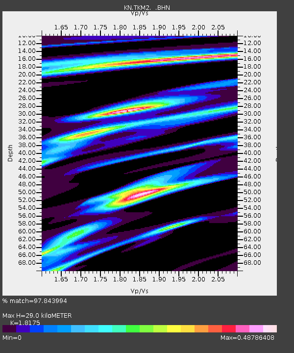
TKM2 KN.TKM2 - Earthquake Result Viewer
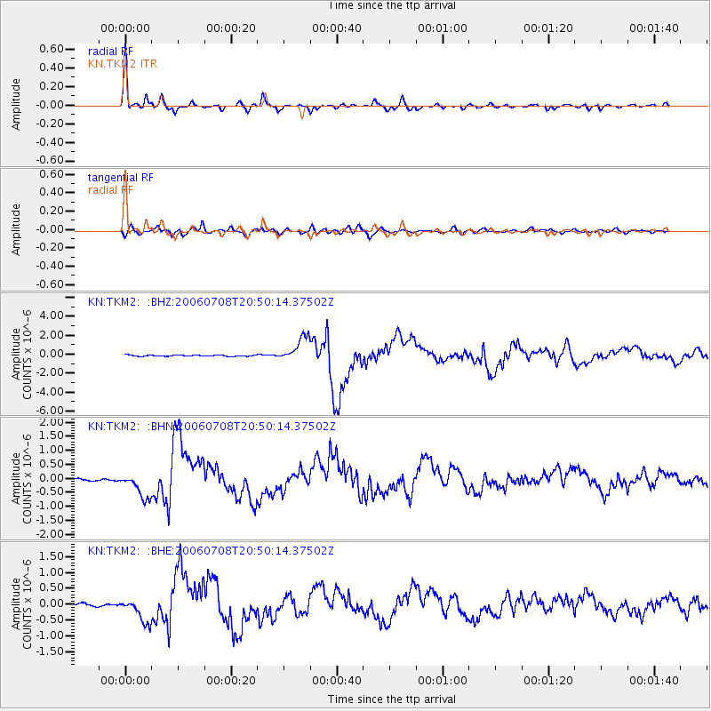
Earthquake location: Andreanof Islands, Aleutian Is.
Earthquake latitude/longitude: 51.2/-179.3
Earthquake time(UTC): 2006/07/08 (189) 20:40:00 GMT
Earthquake Depth: 22 km
Earthquake Magnitude: 6.2 MB, 6.4 MS, 6.6 MW, 6.6 MW
Earthquake Catalog/Contributor: WHDF/NEIC
Network: KN Kyrgyz Seismic Telemetry Network
Station: TKM2 KN.TKM2
Lat/Lon: 42.92 N/75.60 E
Elevation: 2020 m
Distance: 66.0 deg
Az: 309.055 deg
Baz: 41.675 deg
Ray Param: 0.05789681
Estimated Moho Depth: 29.0 km
Estimated Crust Vp/Vs: 1.82
Assumed Crust Vp: 6.306 km/s
Estimated Crust Vs: 3.47 km/s
Estimated Crust Poisson's Ratio: 0.28
Radial Match: 97.843994 %
Radial Bump: 341
Transverse Match: 89.94214 %
Transverse Bump: 400
SOD ConfigId: 2665
Insert Time: 2010-03-08 20:51:38.370 +0000
GWidth: 2.5
Max Bumps: 400
Tol: 0.001

Signal To Noise

ChannelStoNSTALTA
KN:TKM2: :BHN:20060708T20:50:14.37502Z17.473014.6791178E-72.6779118E-8
KN:TKM2: :BHE:20060708T20:50:14.37502Z9.4873843.8195213E-74.025895E-8
KN:TKM2: :BHZ:20060708T20:50:14.37502Z22.3461041.3157799E-65.8881845E-8
Arrivals
Ps3.9 SECOND
PpPs12 SECOND
PsPs/PpSs16 SECOND