You are here: Home > Network List > MM - Myanmar National Seismic Network Stations List
> Station TGI Taung Gyi, Myanmar > Earthquake Result Viewer
TGI Taung Gyi, Myanmar - Earthquake Result Viewer
| Earthquake location: |
Bali Sea |
| Earthquake latitude/longitude: |
-7.0/116.9 |
| Earthquake time(UTC): |
2020/06/03 (155) 15:54:04 GMT |
| Earthquake Depth: |
640 km |
| Earthquake Magnitude: |
5.7 Mww |
| Earthquake Catalog/Contributor: |
NEIC PDE/us |
|
| Network: |
MM Myanmar National Seismic Network |
| Station: |
TGI Taung Gyi, Myanmar |
| Lat/Lon: |
20.77 N/97.03 E |
| Elevation: |
1458 m |
|
| Distance: |
33.8 deg |
| Az: |
325.151 deg |
| Baz: |
142.692 deg |
| Ray Param: |
0.07469925 |
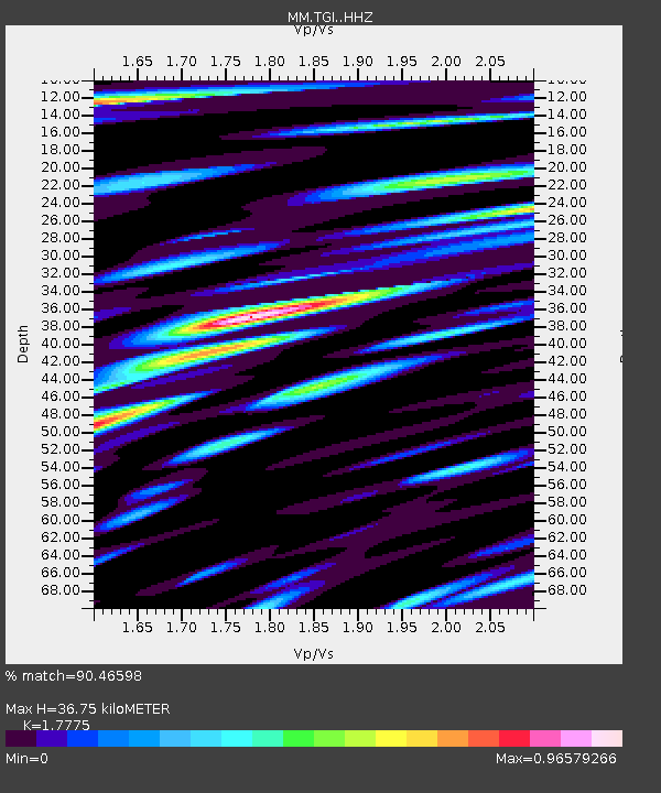
| Estimated Moho Depth: |
36.75 km |
| Estimated Crust Vp/Vs: |
1.78 |
| Assumed Crust Vp: |
6.316 km/s |
| Estimated Crust Vs: |
3.553 km/s |
| Estimated Crust Poisson's Ratio: |
0.27 |
|
| Radial Match: |
90.46598 % |
| Radial Bump: |
400 |
| Transverse Match: |
80.56692 % |
| Transverse Bump: |
400 |
| SOD ConfigId: |
21166931 |
| Insert Time: |
2020-06-17 15:59:38.223 +0000 |
| GWidth: |
2.5 |
| Max Bumps: |
400 |
| Tol: |
0.001 |
|

Signal To Noise
| Channel | StoN | STA | LTA |
| MM:TGI: :HHZ:20200603T15:59:26.110001Z | 77.041695 | 2.4747687E-6 | 3.212246E-8 |
| MM:TGI: :HHN:20200603T15:59:26.110001Z | 28.529587 | 9.548124E-7 | 3.3467447E-8 |
| MM:TGI: :HHE:20200603T15:59:26.110001Z | 34.683987 | 1.4081422E-6 | 4.05992E-8 |
| Arrivals |
| Ps | 4.8 SECOND |
| PpPs | 15 SECOND |
| PsPs/PpSs | 20 SECOND |


