You are here: Home > Network List > TA - USArray Transportable Network (new EarthScope stations) Stations List
> Station H31M Peel River, Yukon, CAN > Earthquake Result Viewer
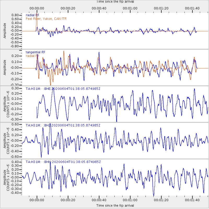
H31M Peel River, Yukon, CAN - Earthquake Result Viewer
*The percent match for this event was below the threshold and hence no stack was calculated.
| Earthquake location: |
Central California |
| Earthquake latitude/longitude: |
35.6/-117.4 |
| Earthquake time(UTC): |
2020/06/04 (156) 01:32:11 GMT |
| Earthquake Depth: |
6.9 km |
| Earthquake Magnitude: |
5.5 mw |
| Earthquake Catalog/Contributor: |
NEIC PDE/ci |
|
| Network: |
TA USArray Transportable Network (new EarthScope stations) |
| Station: |
H31M Peel River, Yukon, CAN |
| Lat/Lon: |
65.81 N/134.34 W |
| Elevation: |
642 m |
|
| Distance: |
31.8 deg |
| Az: |
346.863 deg |
| Baz: |
153.299 deg |
| Ray Param: |
$rayparam |
*The percent match for this event was below the threshold and hence was not used in the summary stack. |
|
| Radial Match: |
53.397327 % |
| Radial Bump: |
400 |
| Transverse Match: |
50.504593 % |
| Transverse Bump: |
400 |
| SOD ConfigId: |
21166931 |
| Insert Time: |
2020-06-18 01:41:50.381 +0000 |
| GWidth: |
2.5 |
| Max Bumps: |
400 |
| Tol: |
0.001 |
|
Signal To Noise
| Channel | StoN | STA | LTA |
| TA:H31M: :BHZ:20200604T01:38:05.874985Z | 3.008792 | 2.5903213E-7 | 8.609174E-8 |
| TA:H31M: :BHN:20200604T01:38:05.874985Z | 1.3050555 | 9.6780944E-8 | 7.415849E-8 |
| TA:H31M: :BHE:20200604T01:38:05.874985Z | 0.88788795 | 1.3547702E-7 | 1.5258347E-7 |
| Arrivals |
| Ps | |
| PpPs | |
| PsPs/PpSs | |


