You are here: Home > Network List > AK - Alaska Regional Network Stations List
> Station A21K Barrow, AK, USA > Earthquake Result Viewer
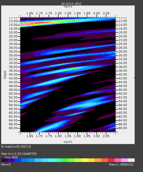
A21K Barrow, AK, USA - Earthquake Result Viewer
| Earthquake location: |
Halmahera, Indonesia |
| Earthquake latitude/longitude: |
2.9/128.2 |
| Earthquake time(UTC): |
2020/06/04 (156) 08:49:41 GMT |
| Earthquake Depth: |
127 km |
| Earthquake Magnitude: |
6.7 Mi |
| Earthquake Catalog/Contributor: |
NEIC PDE/at |
|
| Network: |
AK Alaska Regional Network |
| Station: |
A21K Barrow, AK, USA |
| Lat/Lon: |
71.32 N/156.62 W |
| Elevation: |
5.0 m |
|
| Distance: |
82.5 deg |
| Az: |
18.306 deg |
| Baz: |
256.816 deg |
| Ray Param: |
0.046543937 |
| Estimated Moho Depth: |
13.25 km |
| Estimated Crust Vp/Vs: |
1.61 |
| Assumed Crust Vp: |
6.048 km/s |
| Estimated Crust Vs: |
3.768 km/s |
| Estimated Crust Poisson's Ratio: |
0.18 |
|
| Radial Match: |
92.96716 % |
| Radial Bump: |
347 |
| Transverse Match: |
89.16669 % |
| Transverse Bump: |
364 |
| SOD ConfigId: |
21166931 |
| Insert Time: |
2020-06-18 08:50:07.619 +0000 |
| GWidth: |
2.5 |
| Max Bumps: |
400 |
| Tol: |
0.001 |
|

Signal To Noise
| Channel | StoN | STA | LTA |
| AK:A21K: :BHZ:20200604T09:01:18.500Z | 18.38777 | 7.5805356E-6 | 4.1225965E-7 |
| AK:A21K: :BHN:20200604T09:01:18.500Z | 3.6294692 | 1.1869668E-6 | 3.270359E-7 |
| AK:A21K: :BHE:20200604T09:01:18.500Z | 6.0633144 | 1.6671192E-6 | 2.749518E-7 |
| Arrivals |
| Ps | 1.4 SECOND |
| PpPs | 5.6 SECOND |
| PsPs/PpSs | 6.9 SECOND |


