You are here: Home > Network List > AK - Alaska Regional Network Stations List
> Station CUT Chulitna, AK, USA > Earthquake Result Viewer
CUT Chulitna, AK, USA - Earthquake Result Viewer
| Earthquake location: |
Halmahera, Indonesia |
| Earthquake latitude/longitude: |
2.9/128.2 |
| Earthquake time(UTC): |
2020/06/04 (156) 08:49:41 GMT |
| Earthquake Depth: |
127 km |
| Earthquake Magnitude: |
6.7 Mi |
| Earthquake Catalog/Contributor: |
NEIC PDE/at |
|
| Network: |
AK Alaska Regional Network |
| Station: |
CUT Chulitna, AK, USA |
| Lat/Lon: |
62.41 N/150.26 W |
| Elevation: |
574 m |
|
| Distance: |
83.5 deg |
| Az: |
27.615 deg |
| Baz: |
263.807 deg |
| Ray Param: |
0.045856573 |
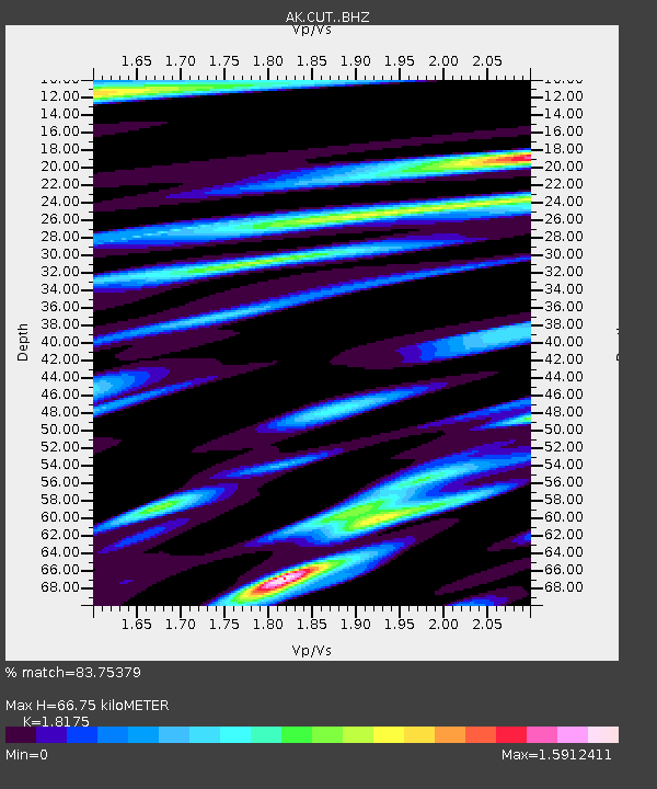
| Estimated Moho Depth: |
66.75 km |
| Estimated Crust Vp/Vs: |
1.82 |
| Assumed Crust Vp: |
6.438 km/s |
| Estimated Crust Vs: |
3.542 km/s |
| Estimated Crust Poisson's Ratio: |
0.28 |
|
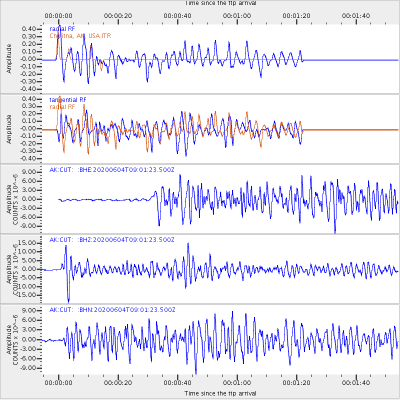
| Radial Match: |
83.75379 % |
| Radial Bump: |
400 |
| Transverse Match: |
81.75932 % |
| Transverse Bump: |
400 |
| SOD ConfigId: |
21166931 |
| Insert Time: |
2020-06-18 08:50:40.105 +0000 |
| GWidth: |
2.5 |
| Max Bumps: |
400 |
| Tol: |
0.001 |
|
Signal To Noise
| Channel | StoN | STA | LTA |
| AK:CUT: :BHZ:20200604T09:01:23.500Z | 73.51975 | 7.136716E-6 | 9.707208E-8 |
| AK:CUT: :BHN:20200604T09:01:23.500Z | 7.4291625 | 1.8967073E-6 | 2.5530568E-7 |
| AK:CUT: :BHE:20200604T09:01:23.500Z | 15.354284 | 2.9287357E-6 | 1.9074388E-7 |
| Arrivals |
| Ps | 8.7 SECOND |
| PpPs | 28 SECOND |
| PsPs/PpSs | 37 SECOND |


