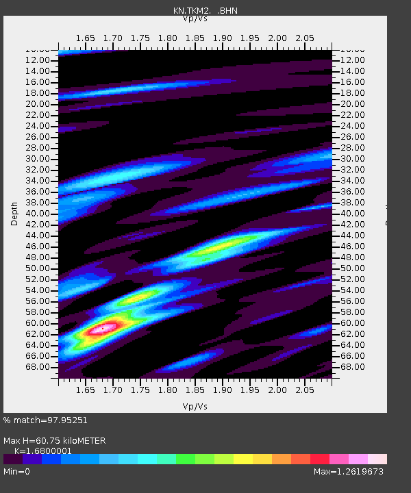
TKM2 KN.TKM2 - Earthquake Result Viewer
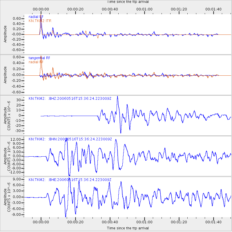
Earthquake location: Northern Sumatra, Indonesia
Earthquake latitude/longitude: 0.1/97.1
Earthquake time(UTC): 2006/05/16 (136) 15:28:25 GMT
Earthquake Depth: 12 km
Earthquake Magnitude: 6.6 MB, 6.8 MS, 6.8 MW, 6.8 MW
Earthquake Catalog/Contributor: WHDF/NEIC
Network: KN Kyrgyz Seismic Telemetry Network
Station: TKM2 KN.TKM2
Lat/Lon: 42.92 N/75.60 E
Elevation: 2020 m
Distance: 46.8 deg
Az: 338.367 deg
Baz: 149.876 deg
Ray Param: 0.07042117
Estimated Moho Depth: 60.75 km
Estimated Crust Vp/Vs: 1.68
Assumed Crust Vp: 6.306 km/s
Estimated Crust Vs: 3.754 km/s
Estimated Crust Poisson's Ratio: 0.23
Radial Match: 97.95251 %
Radial Bump: 400
Transverse Match: 94.11226 %
Transverse Bump: 400
SOD ConfigId: 2669
Insert Time: 2010-03-08 20:52:47.350 +0000
GWidth: 2.5
Max Bumps: 400
Tol: 0.001

Signal To Noise

ChannelStoNSTALTA
KN:TKM2: :BHN:20060516T15:36:24.223009Z26.4163631.1624483E-64.4004857E-8
KN:TKM2: :BHE:20060516T15:36:24.223009Z19.936637.5067766E-73.7653187E-8
KN:TKM2: :BHZ:20060516T15:36:24.223009Z37.143583.1779396E-68.555825E-8
Arrivals
Ps7.0 SECOND
PpPs24 SECOND
PsPs/PpSs31 SECOND