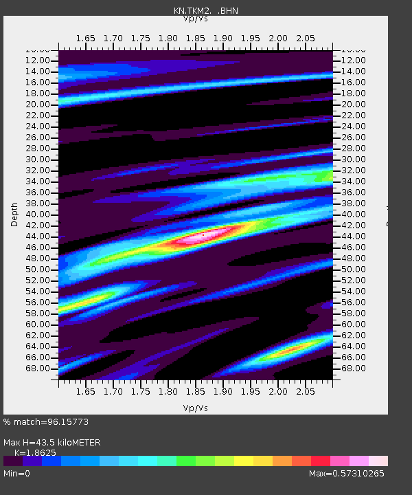
TKM2 KN.TKM2 - Earthquake Result Viewer
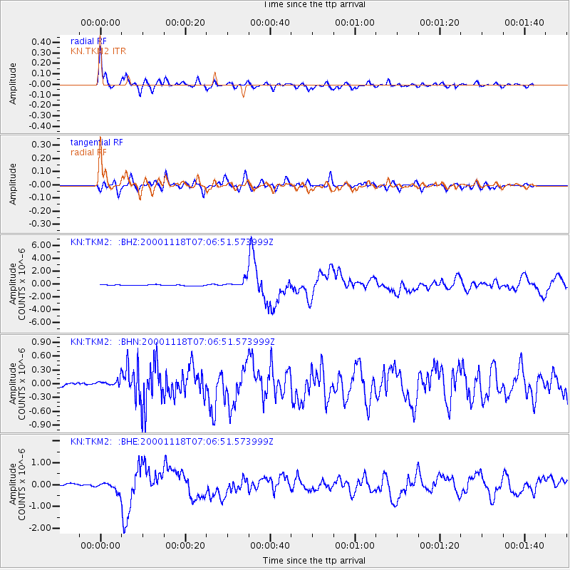
Earthquake location: New Britain Region, P.N.G.
Earthquake latitude/longitude: -5.2/151.8
Earthquake time(UTC): 2000/11/18 (323) 06:54:58 GMT
Earthquake Depth: 33 km
Earthquake Magnitude: 6.2 MB, 6.6 MS, 6.8 MW, 6.8 MW
Earthquake Catalog/Contributor: WHDF/NEIC
Network: KN Kyrgyz Seismic Telemetry Network
Station: TKM2 KN.TKM2
Lat/Lon: 42.92 N/75.60 E
Elevation: 2020 m
Distance: 83.5 deg
Az: 314.117 deg
Baz: 103.265 deg
Ray Param: 0.046108056
Estimated Moho Depth: 43.5 km
Estimated Crust Vp/Vs: 1.86
Assumed Crust Vp: 6.306 km/s
Estimated Crust Vs: 3.386 km/s
Estimated Crust Poisson's Ratio: 0.30
Radial Match: 96.15773 %
Radial Bump: 400
Transverse Match: 86.62995 %
Transverse Bump: 400
SOD ConfigId: 3744
Insert Time: 2010-03-08 20:53:23.537 +0000
GWidth: 2.5
Max Bumps: 400
Tol: 0.001

Signal To Noise

ChannelStoNSTALTA
KN:TKM2: :BHN:20001118T07:06:51.573999Z2.393731.0775177E-74.501417E-8
KN:TKM2: :BHE:20001118T07:06:51.573999Z3.6549082.2419428E-76.134061E-8
KN:TKM2: :BHZ:20001118T07:06:51.573999Z9.3546366.817479E-77.287808E-8
Arrivals
Ps6.1 SECOND
PpPs19 SECOND
PsPs/PpSs25 SECOND