You are here: Home > Network List > AV - Alaska Volcano Observatory Stations List
> Station AHB Akutan Harbor, Akutan Volcano, Alaska > Earthquake Result Viewer
AHB Akutan Harbor, Akutan Volcano, Alaska - Earthquake Result Viewer
| Earthquake location: |
Halmahera, Indonesia |
| Earthquake latitude/longitude: |
2.9/128.2 |
| Earthquake time(UTC): |
2020/06/04 (156) 08:49:41 GMT |
| Earthquake Depth: |
127 km |
| Earthquake Magnitude: |
6.7 Mi |
| Earthquake Catalog/Contributor: |
NEIC PDE/at |
|
| Network: |
AV Alaska Volcano Observatory |
| Station: |
AHB Akutan Harbor, Akutan Volcano, Alaska |
| Lat/Lon: |
54.11 N/165.82 W |
| Elevation: |
447 m |
|
| Distance: |
73.7 deg |
| Az: |
34.062 deg |
| Baz: |
251.825 deg |
| Ray Param: |
0.052508514 |
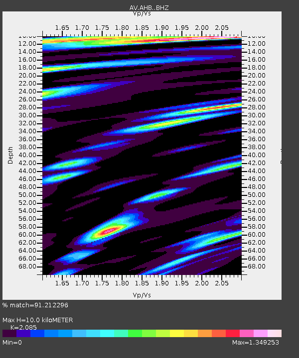
| Estimated Moho Depth: |
10.0 km |
| Estimated Crust Vp/Vs: |
2.09 |
| Assumed Crust Vp: |
5.989 km/s |
| Estimated Crust Vs: |
2.872 km/s |
| Estimated Crust Poisson's Ratio: |
0.35 |
|
| Radial Match: |
91.212296 % |
| Radial Bump: |
400 |
| Transverse Match: |
90.5656 % |
| Transverse Bump: |
400 |
| SOD ConfigId: |
21166931 |
| Insert Time: |
2020-06-18 08:54:10.152 +0000 |
| GWidth: |
2.5 |
| Max Bumps: |
400 |
| Tol: |
0.001 |
|

Signal To Noise
| Channel | StoN | STA | LTA |
| AV:AHB: :BHZ:20200604T09:00:30.158997Z | 27.666979 | 4.8101247E-6 | 1.7385796E-7 |
| AV:AHB: :BHN:20200604T09:00:30.158997Z | 5.6714234 | 1.3544517E-6 | 2.388204E-7 |
| AV:AHB: :BHE:20200604T09:00:30.158997Z | 9.49485 | 1.976226E-6 | 2.0813661E-7 |
| Arrivals |
| Ps | 1.9 SECOND |
| PpPs | 5.0 SECOND |
| PsPs/PpSs | 6.9 SECOND |


