You are here: Home > Network List > AV - Alaska Volcano Observatory Stations List
> Station GALA Lava Point, Gareloi Volcano, Alaska > Earthquake Result Viewer
GALA Lava Point, Gareloi Volcano, Alaska - Earthquake Result Viewer
| Earthquake location: |
Halmahera, Indonesia |
| Earthquake latitude/longitude: |
2.9/128.2 |
| Earthquake time(UTC): |
2020/06/04 (156) 08:49:41 GMT |
| Earthquake Depth: |
127 km |
| Earthquake Magnitude: |
6.7 Mi |
| Earthquake Catalog/Contributor: |
NEIC PDE/at |
|
| Network: |
AV Alaska Volcano Observatory |
| Station: |
GALA Lava Point, Gareloi Volcano, Alaska |
| Lat/Lon: |
51.76 N/178.77 W |
| Elevation: |
315 m |
|
| Distance: |
65.6 deg |
| Az: |
33.022 deg |
| Baz: |
241.131 deg |
| Ray Param: |
0.057814997 |
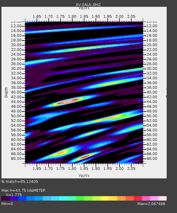
| Estimated Moho Depth: |
43.75 km |
| Estimated Crust Vp/Vs: |
1.77 |
| Assumed Crust Vp: |
6.048 km/s |
| Estimated Crust Vs: |
3.407 km/s |
| Estimated Crust Poisson's Ratio: |
0.27 |
|
| Radial Match: |
85.12405 % |
| Radial Bump: |
400 |
| Transverse Match: |
81.85041 % |
| Transverse Bump: |
400 |
| SOD ConfigId: |
21166931 |
| Insert Time: |
2020-06-18 08:54:48.464 +0000 |
| GWidth: |
2.5 |
| Max Bumps: |
400 |
| Tol: |
0.001 |
|

Signal To Noise
| Channel | StoN | STA | LTA |
| AV:GALA: :BHZ:20200604T08:59:40.539978Z | 25.511953 | 5.5288965E-6 | 2.1671788E-7 |
| AV:GALA: :BHN:20200604T08:59:40.539978Z | 13.523239 | 4.9703426E-6 | 3.6754085E-7 |
| AV:GALA: :BHE:20200604T08:59:40.539978Z | 7.455934 | 3.3401518E-6 | 4.4798568E-7 |
| Arrivals |
| Ps | 5.8 SECOND |
| PpPs | 19 SECOND |
| PsPs/PpSs | 25 SECOND |


