You are here: Home > Network List > AV - Alaska Volcano Observatory Stations List
> Station GSIG Igitkin Island, Great Sitkin Volcano, Alaska > Earthquake Result Viewer
GSIG Igitkin Island, Great Sitkin Volcano, Alaska - Earthquake Result Viewer
| Earthquake location: |
Halmahera, Indonesia |
| Earthquake latitude/longitude: |
2.9/128.2 |
| Earthquake time(UTC): |
2020/06/04 (156) 08:49:41 GMT |
| Earthquake Depth: |
127 km |
| Earthquake Magnitude: |
6.7 Mi |
| Earthquake Catalog/Contributor: |
NEIC PDE/at |
|
| Network: |
AV Alaska Volcano Observatory |
| Station: |
GSIG Igitkin Island, Great Sitkin Volcano, Alaska |
| Lat/Lon: |
51.99 N/175.93 W |
| Elevation: |
407 m |
|
| Distance: |
67.3 deg |
| Az: |
33.697 deg |
| Baz: |
243.634 deg |
| Ray Param: |
0.05673202 |
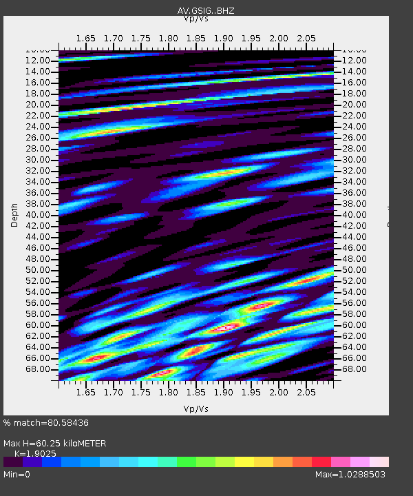
| Estimated Moho Depth: |
60.25 km |
| Estimated Crust Vp/Vs: |
1.90 |
| Assumed Crust Vp: |
3.943 km/s |
| Estimated Crust Vs: |
2.073 km/s |
| Estimated Crust Poisson's Ratio: |
0.31 |
|
| Radial Match: |
80.58436 % |
| Radial Bump: |
400 |
| Transverse Match: |
71.22952 % |
| Transverse Bump: |
400 |
| SOD ConfigId: |
21166931 |
| Insert Time: |
2020-06-18 08:54:54.723 +0000 |
| GWidth: |
2.5 |
| Max Bumps: |
400 |
| Tol: |
0.001 |
|

Signal To Noise
| Channel | StoN | STA | LTA |
| AV:GSIG: :BHZ:20200604T08:59:51.119995Z | 58.45454 | 5.673003E-6 | 9.704983E-8 |
| AV:GSIG: :BHN:20200604T08:59:51.119995Z | 3.2406719 | 1.0122269E-6 | 3.1235095E-7 |
| AV:GSIG: :BHE:20200604T08:59:51.119995Z | 10.868678 | 2.232167E-6 | 2.0537614E-7 |
| Arrivals |
| Ps | 14 SECOND |
| PpPs | 44 SECOND |
| PsPs/PpSs | 58 SECOND |


