You are here: Home > Network List > AV - Alaska Volcano Observatory Stations List
> Station ILS Iliamna South, Iliamna Volcano, Alaska > Earthquake Result Viewer
ILS Iliamna South, Iliamna Volcano, Alaska - Earthquake Result Viewer
| Earthquake location: |
Halmahera, Indonesia |
| Earthquake latitude/longitude: |
2.9/128.2 |
| Earthquake time(UTC): |
2020/06/04 (156) 08:49:41 GMT |
| Earthquake Depth: |
127 km |
| Earthquake Magnitude: |
6.7 Mi |
| Earthquake Catalog/Contributor: |
NEIC PDE/at |
|
| Network: |
AV Alaska Volcano Observatory |
| Station: |
ILS Iliamna South, Iliamna Volcano, Alaska |
| Lat/Lon: |
59.96 N/153.07 W |
| Elevation: |
1125 m |
|
| Distance: |
81.8 deg |
| Az: |
29.898 deg |
| Baz: |
261.642 deg |
| Ray Param: |
0.04701706 |
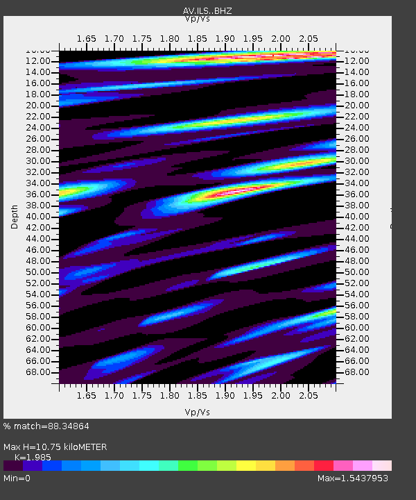
| Estimated Moho Depth: |
10.75 km |
| Estimated Crust Vp/Vs: |
1.99 |
| Assumed Crust Vp: |
5.989 km/s |
| Estimated Crust Vs: |
3.017 km/s |
| Estimated Crust Poisson's Ratio: |
0.33 |
|
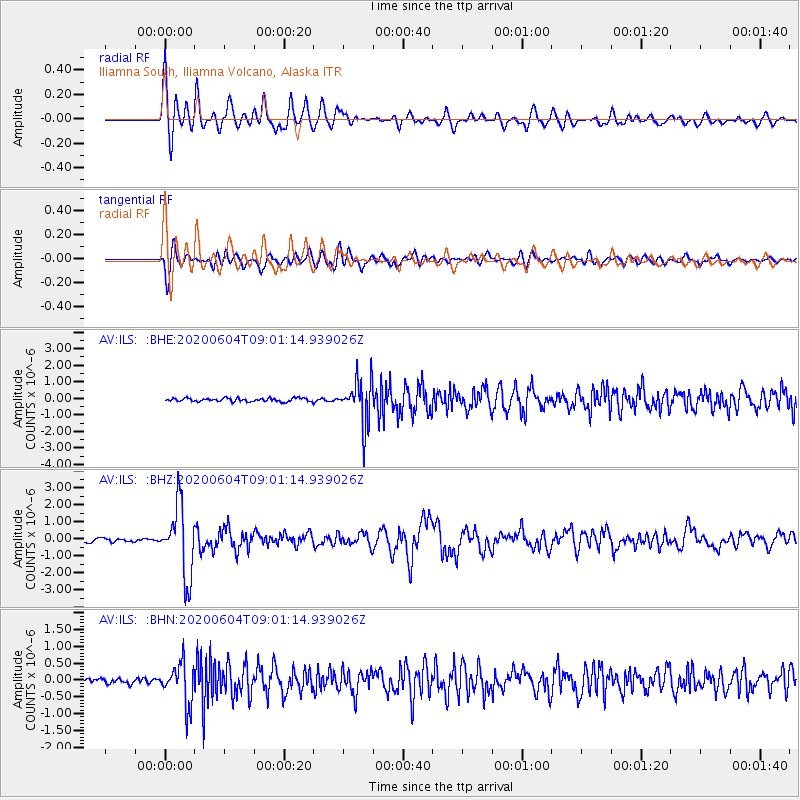
| Radial Match: |
88.34864 % |
| Radial Bump: |
400 |
| Transverse Match: |
82.884476 % |
| Transverse Bump: |
400 |
| SOD ConfigId: |
21166931 |
| Insert Time: |
2020-06-18 08:55:02.918 +0000 |
| GWidth: |
2.5 |
| Max Bumps: |
400 |
| Tol: |
0.001 |
|
Signal To Noise
| Channel | StoN | STA | LTA |
| AV:ILS: :BHZ:20200604T09:01:14.939026Z | 18.765038 | 2.050058E-6 | 1.0924881E-7 |
| AV:ILS: :BHN:20200604T09:01:14.939026Z | 6.7503924 | 6.189875E-7 | 9.169652E-8 |
| AV:ILS: :BHE:20200604T09:01:14.939026Z | 12.815526 | 1.295652E-6 | 1.01100184E-7 |
| Arrivals |
| Ps | 1.8 SECOND |
| PpPs | 5.2 SECOND |
| PsPs/PpSs | 7.1 SECOND |


