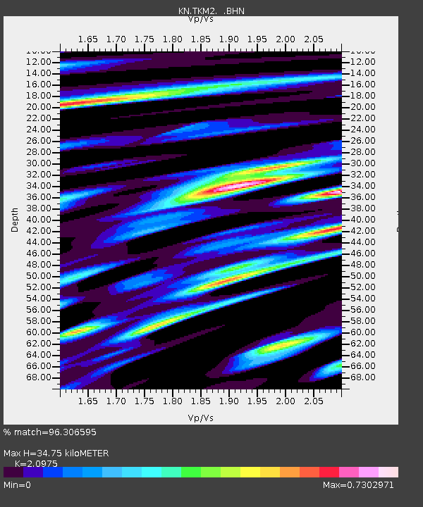
TKM2 KN.TKM2 - Earthquake Result Viewer
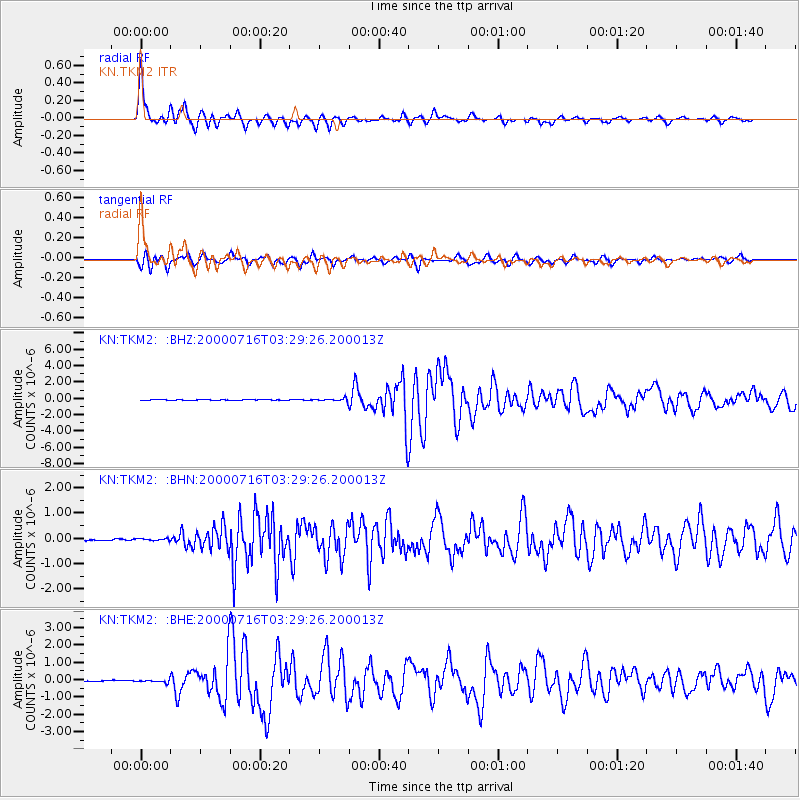
Earthquake location: Philippine Islands Region
Earthquake latitude/longitude: 20.3/122.0
Earthquake time(UTC): 2000/07/16 (198) 03:21:45 GMT
Earthquake Depth: 33 km
Earthquake Magnitude: 6.1 MB, 6.3 MS, 6.4 MW, 6.4 MW
Earthquake Catalog/Contributor: WHDF/NEIC
Network: KN Kyrgyz Seismic Telemetry Network
Station: TKM2 KN.TKM2
Lat/Lon: 42.92 N/75.60 E
Elevation: 2020 m
Distance: 44.9 deg
Az: 311.008 deg
Baz: 105.303 deg
Ray Param: 0.07158597
Estimated Moho Depth: 34.75 km
Estimated Crust Vp/Vs: 2.10
Assumed Crust Vp: 6.306 km/s
Estimated Crust Vs: 3.006 km/s
Estimated Crust Poisson's Ratio: 0.35
Radial Match: 96.306595 %
Radial Bump: 352
Transverse Match: 87.624374 %
Transverse Bump: 400
SOD ConfigId: 3744
Insert Time: 2010-03-08 20:53:43.492 +0000
GWidth: 2.5
Max Bumps: 400
Tol: 0.001

Signal To Noise

ChannelStoNSTALTA
KN:TKM2: :BHN:20000716T03:29:26.200013Z2.24409825.1050993E-82.2749001E-8
KN:TKM2: :BHE:20000716T03:29:26.200013Z3.17591957.505181E-82.363152E-8
KN:TKM2: :BHZ:20000716T03:29:26.200013Z4.64167641.7497496E-73.76965E-8
Arrivals
Ps6.4 SECOND
PpPs16 SECOND
PsPs/PpSs23 SECOND