You are here: Home > Network List > AV - Alaska Volcano Observatory Stations List
> Station SPCR Ckakachatna River, Mount Spurr, Alaska > Earthquake Result Viewer
SPCR Ckakachatna River, Mount Spurr, Alaska - Earthquake Result Viewer
| Earthquake location: |
Halmahera, Indonesia |
| Earthquake latitude/longitude: |
2.9/128.2 |
| Earthquake time(UTC): |
2020/06/04 (156) 08:49:41 GMT |
| Earthquake Depth: |
127 km |
| Earthquake Magnitude: |
6.7 Mi |
| Earthquake Catalog/Contributor: |
NEIC PDE/at |
|
| Network: |
AV Alaska Volcano Observatory |
| Station: |
SPCR Ckakachatna River, Mount Spurr, Alaska |
| Lat/Lon: |
61.20 N/152.21 W |
| Elevation: |
984 m |
|
| Distance: |
82.4 deg |
| Az: |
28.711 deg |
| Baz: |
262.228 deg |
| Ray Param: |
0.046607714 |
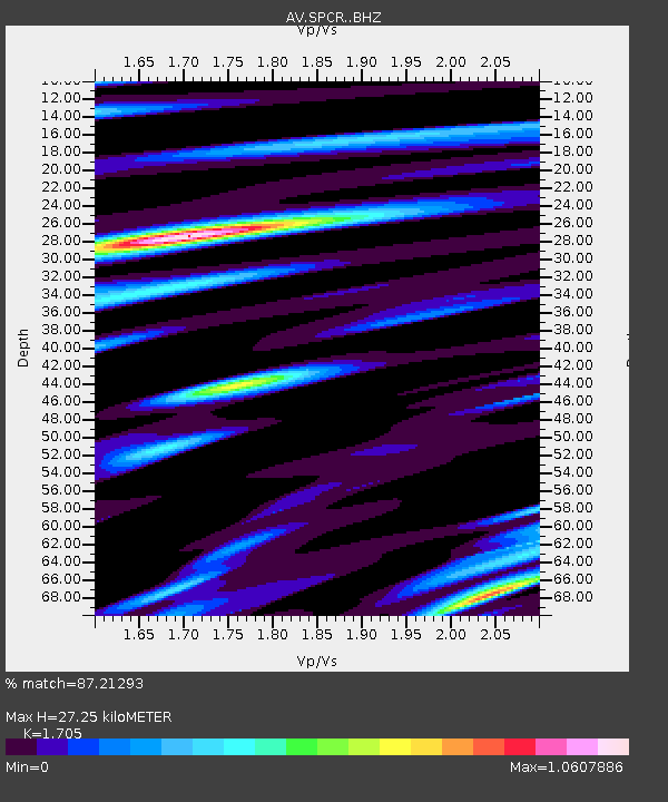
| Estimated Moho Depth: |
27.25 km |
| Estimated Crust Vp/Vs: |
1.71 |
| Assumed Crust Vp: |
6.566 km/s |
| Estimated Crust Vs: |
3.851 km/s |
| Estimated Crust Poisson's Ratio: |
0.24 |
|
| Radial Match: |
87.21293 % |
| Radial Bump: |
400 |
| Transverse Match: |
89.595116 % |
| Transverse Bump: |
400 |
| SOD ConfigId: |
21166931 |
| Insert Time: |
2020-06-18 08:56:00.391 +0000 |
| GWidth: |
2.5 |
| Max Bumps: |
400 |
| Tol: |
0.001 |
|

Signal To Noise
| Channel | StoN | STA | LTA |
| AV:SPCR: :BHZ:20200604T09:01:18.039978Z | 26.67104 | 4.7115986E-6 | 1.7665597E-7 |
| AV:SPCR: :BHN:20200604T09:01:18.039978Z | 5.1197395 | 5.145439E-7 | 1.00501964E-7 |
| AV:SPCR: :BHE:20200604T09:01:18.039978Z | 8.778516 | 1.043208E-6 | 1.1883649E-7 |
| Arrivals |
| Ps | 3.0 SECOND |
| PpPs | 11 SECOND |
| PsPs/PpSs | 14 SECOND |


