You are here: Home > Network List > II - Global Seismograph Network (GSN - IRIS/IDA) Stations List
> Station KURK Kurchatov, Kazakhstan > Earthquake Result Viewer
KURK Kurchatov, Kazakhstan - Earthquake Result Viewer
| Earthquake location: |
Halmahera, Indonesia |
| Earthquake latitude/longitude: |
2.9/128.2 |
| Earthquake time(UTC): |
2020/06/04 (156) 08:49:41 GMT |
| Earthquake Depth: |
127 km |
| Earthquake Magnitude: |
6.7 Mi |
| Earthquake Catalog/Contributor: |
NEIC PDE/at |
|
| Network: |
II Global Seismograph Network (GSN - IRIS/IDA) |
| Station: |
KURK Kurchatov, Kazakhstan |
| Lat/Lon: |
50.72 N/78.62 E |
| Elevation: |
184 m |
|
| Distance: |
63.2 deg |
| Az: |
327.161 deg |
| Baz: |
121.576 deg |
| Ray Param: |
0.05934667 |
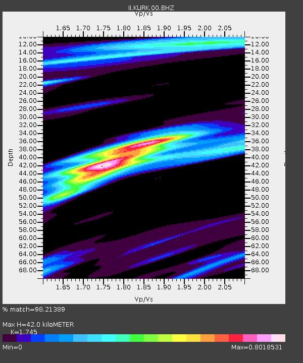
| Estimated Moho Depth: |
42.0 km |
| Estimated Crust Vp/Vs: |
1.75 |
| Assumed Crust Vp: |
6.552 km/s |
| Estimated Crust Vs: |
3.755 km/s |
| Estimated Crust Poisson's Ratio: |
0.26 |
|
| Radial Match: |
98.21389 % |
| Radial Bump: |
250 |
| Transverse Match: |
92.40295 % |
| Transverse Bump: |
400 |
| SOD ConfigId: |
21166931 |
| Insert Time: |
2020-06-18 08:58:12.702 +0000 |
| GWidth: |
2.5 |
| Max Bumps: |
400 |
| Tol: |
0.001 |
|

Signal To Noise
| Channel | StoN | STA | LTA |
| II:KURK:00:BHZ:20200604T08:59:25.218994Z | 231.25856 | 1.0502571E-5 | 4.5414843E-8 |
| II:KURK:00:BH1:20200604T08:59:25.218994Z | 42.192436 | 1.3791415E-6 | 3.2686938E-8 |
| II:KURK:00:BH2:20200604T08:59:25.218994Z | 78.96195 | 4.235828E-6 | 5.364391E-8 |
| Arrivals |
| Ps | 5.0 SECOND |
| PpPs | 17 SECOND |
| PsPs/PpSs | 22 SECOND |


