You are here: Home > Network List > KN - Kyrgyz Seismic Telemetry Network Stations List
> Station TKM2 KN.TKM2 > Earthquake Result Viewer
TKM2 KN.TKM2 - Earthquake Result Viewer
| Earthquake location: |
Bonin Islands, Japan Region |
| Earthquake latitude/longitude: |
28.9/139.6 |
| Earthquake time(UTC): |
2000/08/06 (219) 07:27:12 GMT |
| Earthquake Depth: |
395 km |
| Earthquake Magnitude: |
6.3 MB, 7.3 MW, 7.3 MW |
| Earthquake Catalog/Contributor: |
WHDF/NEIC |
|
| Network: |
KN Kyrgyz Seismic Telemetry Network |
| Station: |
TKM2 KN.TKM2 |
| Lat/Lon: |
42.92 N/75.60 E |
| Elevation: |
2020 m |
|
| Distance: |
52.5 deg |
| Az: |
303.713 deg |
| Baz: |
83.386 deg |
| Ray Param: |
0.06514108 |
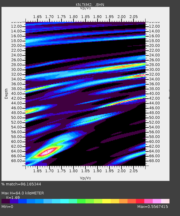
| Estimated Moho Depth: |
64.0 km |
| Estimated Crust Vp/Vs: |
1.69 |
| Assumed Crust Vp: |
6.306 km/s |
| Estimated Crust Vs: |
3.731 km/s |
| Estimated Crust Poisson's Ratio: |
0.23 |
|
| Radial Match: |
96.165344 % |
| Radial Bump: |
400 |
| Transverse Match: |
89.57411 % |
| Transverse Bump: |
400 |
| SOD ConfigId: |
3744 |
| Insert Time: |
2010-03-08 20:54:19.142 +0000 |
| GWidth: |
2.5 |
| Max Bumps: |
400 |
| Tol: |
0.001 |
|
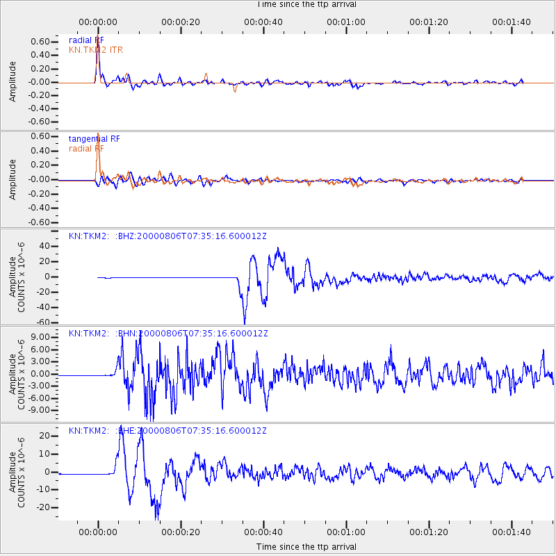
Signal To Noise
| Channel | StoN | STA | LTA |
| KN:TKM2: :BHN:20000806T07:35:16.600012Z | 33.078606 | 1.0454859E-6 | 3.1606106E-8 |
| KN:TKM2: :BHE:20000806T07:35:16.600012Z | 22.85673 | 3.4240668E-6 | 1.4980563E-7 |
| KN:TKM2: :BHZ:20000806T07:35:16.600012Z | 34.92464 | 8.244766E-6 | 2.3607305E-7 |
| Arrivals |
| Ps | 7.4 SECOND |
| PpPs | 26 SECOND |
| PsPs/PpSs | 33 SECOND |


