You are here: Home > Network List > JP - Japan Meteorological Agency Seismic Network Stations List
> Station JTU Tsushima Kamiagata > Earthquake Result Viewer
JTU Tsushima Kamiagata - Earthquake Result Viewer
| Earthquake location: |
Halmahera, Indonesia |
| Earthquake latitude/longitude: |
2.9/128.2 |
| Earthquake time(UTC): |
2020/06/04 (156) 08:49:41 GMT |
| Earthquake Depth: |
127 km |
| Earthquake Magnitude: |
6.7 Mi |
| Earthquake Catalog/Contributor: |
NEIC PDE/at |
|
| Network: |
JP Japan Meteorological Agency Seismic Network |
| Station: |
JTU Tsushima Kamiagata |
| Lat/Lon: |
34.53 N/129.40 E |
| Elevation: |
70 m |
|
| Distance: |
31.5 deg |
| Az: |
1.838 deg |
| Baz: |
182.223 deg |
| Ray Param: |
0.07872028 |
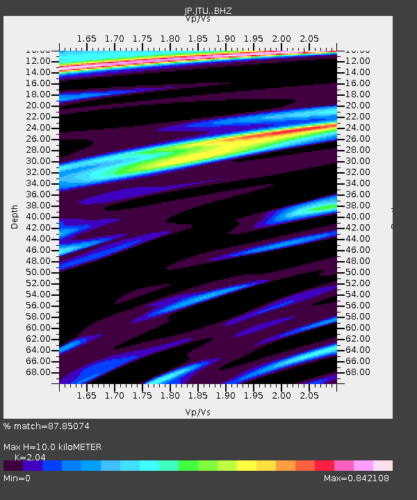
| Estimated Moho Depth: |
10.0 km |
| Estimated Crust Vp/Vs: |
2.04 |
| Assumed Crust Vp: |
6.472 km/s |
| Estimated Crust Vs: |
3.172 km/s |
| Estimated Crust Poisson's Ratio: |
0.34 |
|
| Radial Match: |
87.85074 % |
| Radial Bump: |
240 |
| Transverse Match: |
71.52439 % |
| Transverse Bump: |
400 |
| SOD ConfigId: |
21166931 |
| Insert Time: |
2020-06-18 08:59:21.507 +0000 |
| GWidth: |
2.5 |
| Max Bumps: |
400 |
| Tol: |
0.001 |
|

Signal To Noise
| Channel | StoN | STA | LTA |
| JP:JTU: :BHZ:20200604T08:55:20.500Z | 55.97539 | 9.378574E-6 | 1.6754815E-7 |
| JP:JTU: :BHN:20200604T08:55:20.500Z | 57.08975 | 6.2479476E-6 | 1.094408E-7 |
| JP:JTU: :BHE:20200604T08:55:20.500Z | 7.0317917 | 8.8715433E-7 | 1.2616333E-7 |
| Arrivals |
| Ps | 1.7 SECOND |
| PpPs | 4.4 SECOND |
| PsPs/PpSs | 6.1 SECOND |


