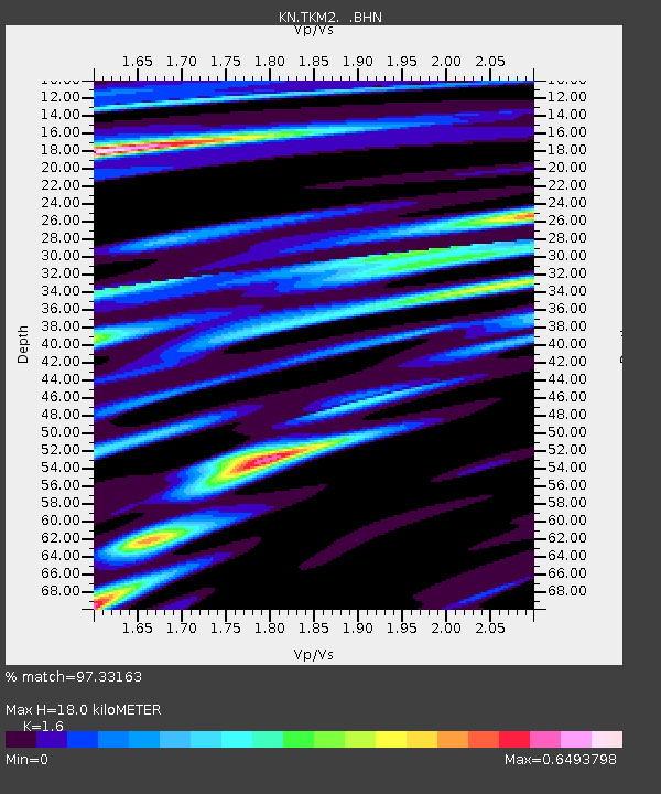
TKM2 KN.TKM2 - Earthquake Result Viewer
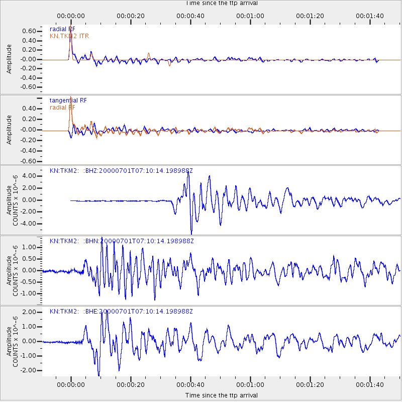
Earthquake location: Near S. Coast Of Honshu, Japan
Earthquake latitude/longitude: 34.2/139.1
Earthquake time(UTC): 2000/07/01 (183) 07:01:55 GMT
Earthquake Depth: 10 km
Earthquake Magnitude: 6.0 MB, 6.1 MS, 6.2 MW, 6.2 MW
Earthquake Catalog/Contributor: WHDF/NEIC
Network: KN Kyrgyz Seismic Telemetry Network
Station: TKM2 KN.TKM2
Lat/Lon: 42.92 N/75.60 E
Elevation: 2020 m
Distance: 49.4 deg
Az: 299.956 deg
Baz: 77.78 deg
Ray Param: 0.0687407
Estimated Moho Depth: 18.0 km
Estimated Crust Vp/Vs: 1.60
Assumed Crust Vp: 6.306 km/s
Estimated Crust Vs: 3.941 km/s
Estimated Crust Poisson's Ratio: 0.18
Radial Match: 97.33163 %
Radial Bump: 339
Transverse Match: 91.36343 %
Transverse Bump: 400
SOD ConfigId: 3744
Insert Time: 2010-03-08 20:54:28.395 +0000
GWidth: 2.5
Max Bumps: 400
Tol: 0.001

Signal To Noise

ChannelStoNSTALTA
KN:TKM2: :BHN:20000701T07:10:14.198988Z2.3323151.2048531E-75.1659107E-8
KN:TKM2: :BHE:20000701T07:10:14.198988Z11.9105142.7562075E-72.3140963E-8
KN:TKM2: :BHZ:20000701T07:10:14.198988Z19.085315.968044E-73.1270353E-8
Arrivals
Ps1.8 SECOND
PpPs7.0 SECOND
PsPs/PpSs8.8 SECOND