You are here: Home > Network List > KR - Kyrgyz Digital Network Stations List
> Station TRKS Terek-Say, Kyrgyzstan > Earthquake Result Viewer
TRKS Terek-Say, Kyrgyzstan - Earthquake Result Viewer
| Earthquake location: |
Halmahera, Indonesia |
| Earthquake latitude/longitude: |
2.9/128.2 |
| Earthquake time(UTC): |
2020/06/04 (156) 08:49:41 GMT |
| Earthquake Depth: |
127 km |
| Earthquake Magnitude: |
6.7 Mi |
| Earthquake Catalog/Contributor: |
NEIC PDE/at |
|
| Network: |
KR Kyrgyz Digital Network |
| Station: |
TRKS Terek-Say, Kyrgyzstan |
| Lat/Lon: |
41.46 N/71.17 E |
| Elevation: |
1518 m |
|
| Distance: |
63.8 deg |
| Az: |
315.338 deg |
| Baz: |
110.922 deg |
| Ray Param: |
0.058970053 |
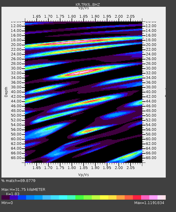
| Estimated Moho Depth: |
31.75 km |
| Estimated Crust Vp/Vs: |
1.83 |
| Assumed Crust Vp: |
6.236 km/s |
| Estimated Crust Vs: |
3.408 km/s |
| Estimated Crust Poisson's Ratio: |
0.29 |
|
| Radial Match: |
89.8779 % |
| Radial Bump: |
400 |
| Transverse Match: |
83.61377 % |
| Transverse Bump: |
400 |
| SOD ConfigId: |
21166931 |
| Insert Time: |
2020-06-18 08:59:58.315 +0000 |
| GWidth: |
2.5 |
| Max Bumps: |
400 |
| Tol: |
0.001 |
|

Signal To Noise
| Channel | StoN | STA | LTA |
| KR:TRKS: :BHZ:20200604T08:59:28.940002Z | 177.33163 | 6.667755E-6 | 3.7600483E-8 |
| KR:TRKS: :BHN:20200604T08:59:28.940002Z | 29.174381 | 1.4547173E-6 | 4.9862834E-8 |
| KR:TRKS: :BHE:20200604T08:59:28.940002Z | 34.233273 | 2.9620353E-6 | 8.6525034E-8 |
| Arrivals |
| Ps | 4.4 SECOND |
| PpPs | 14 SECOND |
| PsPs/PpSs | 18 SECOND |


