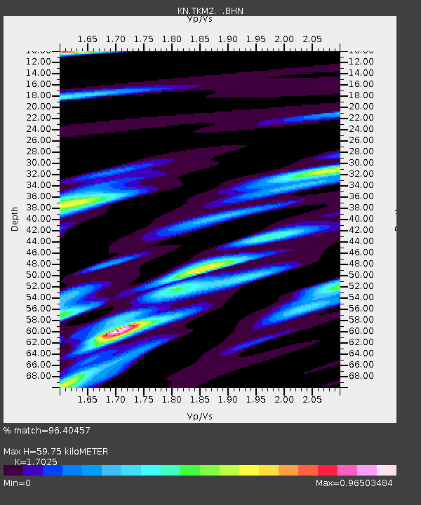
TKM2 KN.TKM2 - Earthquake Result Viewer
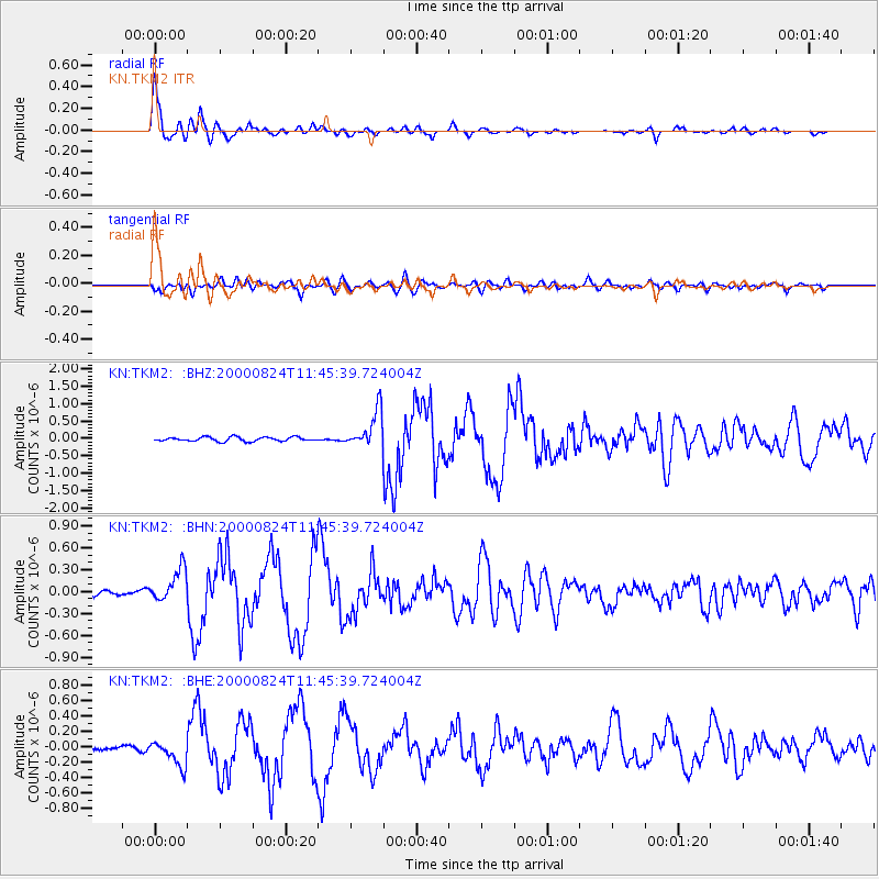
Earthquake location: Southwest Of Sumatra, Indonesia
Earthquake latitude/longitude: -6.0/102.7
Earthquake time(UTC): 2000/08/24 (237) 11:36:45 GMT
Earthquake Depth: 33 km
Earthquake Magnitude: 5.7 MB, 5.9 MS, 6.0 MW, 5.8 MW
Earthquake Catalog/Contributor: WHDF/NEIC
Network: KN Kyrgyz Seismic Telemetry Network
Station: TKM2 KN.TKM2
Lat/Lon: 42.92 N/75.60 E
Elevation: 2020 m
Distance: 54.6 deg
Az: 335.762 deg
Baz: 146.233 deg
Ray Param: 0.06530561
Estimated Moho Depth: 59.75 km
Estimated Crust Vp/Vs: 1.70
Assumed Crust Vp: 6.306 km/s
Estimated Crust Vs: 3.704 km/s
Estimated Crust Poisson's Ratio: 0.24
Radial Match: 96.40457 %
Radial Bump: 317
Transverse Match: 85.2046 %
Transverse Bump: 400
SOD ConfigId: 3744
Insert Time: 2010-03-08 20:54:37.769 +0000
GWidth: 2.5
Max Bumps: 400
Tol: 0.001

Signal To Noise

ChannelStoNSTALTA
KN:TKM2: :BHN:20000824T11:45:39.724004Z5.969442.3772044E-73.9822904E-8
KN:TKM2: :BHE:20000824T11:45:39.724004Z4.8754661.5671104E-73.2142783E-8
KN:TKM2: :BHZ:20000824T11:45:39.724004Z8.9600075.3096227E-75.9259136E-8
Arrivals
Ps7.0 SECOND
PpPs24 SECOND
PsPs/PpSs31 SECOND