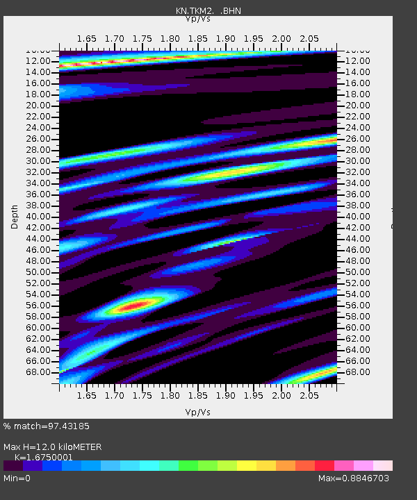
TKM2 KN.TKM2 - Earthquake Result Viewer
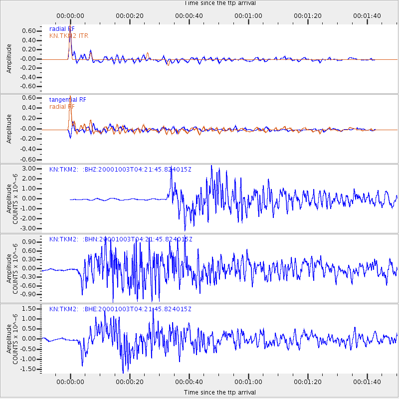
Earthquake location: Off East Coast Of Honshu, Japan
Earthquake latitude/longitude: 40.3/143.1
Earthquake time(UTC): 2000/10/03 (277) 04:13:30 GMT
Earthquake Depth: 33 km
Earthquake Magnitude: 5.6 MB, 5.7 MS, 6.1 MW, 6.0 MW
Earthquake Catalog/Contributor: WHDF/NEIC
Network: KN Kyrgyz Seismic Telemetry Network
Station: TKM2 KN.TKM2
Lat/Lon: 42.92 N/75.60 E
Elevation: 2020 m
Distance: 49.3 deg
Az: 296.488 deg
Baz: 68.767 deg
Ray Param: 0.06871087
Estimated Moho Depth: 12.0 km
Estimated Crust Vp/Vs: 1.68
Assumed Crust Vp: 6.306 km/s
Estimated Crust Vs: 3.765 km/s
Estimated Crust Poisson's Ratio: 0.22
Radial Match: 97.43185 %
Radial Bump: 400
Transverse Match: 90.21524 %
Transverse Bump: 400
SOD ConfigId: 3744
Insert Time: 2010-03-08 20:54:48.108 +0000
GWidth: 2.5
Max Bumps: 400
Tol: 0.001

Signal To Noise

ChannelStoNSTALTA
KN:TKM2: :BHN:20001003T04:21:45.824015Z5.40132.62958E-74.8684207E-8
KN:TKM2: :BHE:20001003T04:21:45.824015Z11.0610053.67815E-73.325331E-8
KN:TKM2: :BHZ:20001003T04:21:45.824015Z16.1498498.9836465E-75.5626813E-8
Arrivals
Ps1.4 SECOND
PpPs4.8 SECOND
PsPs/PpSs6.2 SECOND