You are here: Home > Network List > TA - USArray Transportable Network (new EarthScope stations) Stations List
> Station G15K Niukluk, AK, USA > Earthquake Result Viewer
G15K Niukluk, AK, USA - Earthquake Result Viewer
| Earthquake location: |
Halmahera, Indonesia |
| Earthquake latitude/longitude: |
2.9/128.2 |
| Earthquake time(UTC): |
2020/06/04 (156) 08:49:41 GMT |
| Earthquake Depth: |
127 km |
| Earthquake Magnitude: |
6.7 Mi |
| Earthquake Catalog/Contributor: |
NEIC PDE/at |
|
| Network: |
TA USArray Transportable Network (new EarthScope stations) |
| Station: |
G15K Niukluk, AK, USA |
| Lat/Lon: |
64.99 N/164.04 W |
| Elevation: |
249 m |
|
| Distance: |
78.1 deg |
| Az: |
23.703 deg |
| Baz: |
250.832 deg |
| Ray Param: |
0.049579106 |
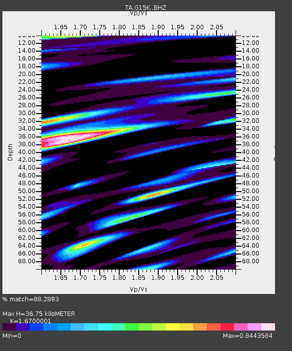
| Estimated Moho Depth: |
36.75 km |
| Estimated Crust Vp/Vs: |
1.67 |
| Assumed Crust Vp: |
6.276 km/s |
| Estimated Crust Vs: |
3.758 km/s |
| Estimated Crust Poisson's Ratio: |
0.22 |
|
| Radial Match: |
88.2893 % |
| Radial Bump: |
400 |
| Transverse Match: |
84.48904 % |
| Transverse Bump: |
400 |
| SOD ConfigId: |
21166931 |
| Insert Time: |
2020-06-18 09:02:30.768 +0000 |
| GWidth: |
2.5 |
| Max Bumps: |
400 |
| Tol: |
0.001 |
|

Signal To Noise
| Channel | StoN | STA | LTA |
| TA:G15K: :BHZ:20200604T09:00:54.849976Z | 41.452026 | 2.7606525E-6 | 6.659874E-8 |
| TA:G15K: :BHN:20200604T09:00:54.849976Z | 5.1681423 | 2.1725839E-7 | 4.2038003E-8 |
| TA:G15K: :BHE:20200604T09:00:54.849976Z | 17.32156 | 8.399506E-7 | 4.8491625E-8 |
| Arrivals |
| Ps | 4.0 SECOND |
| PpPs | 15 SECOND |
| PsPs/PpSs | 19 SECOND |


