You are here: Home > Network List > TA - USArray Transportable Network (new EarthScope stations) Stations List
> Station G17K Kiwalik Mountain, AK, USA > Earthquake Result Viewer
G17K Kiwalik Mountain, AK, USA - Earthquake Result Viewer
| Earthquake location: |
Halmahera, Indonesia |
| Earthquake latitude/longitude: |
2.9/128.2 |
| Earthquake time(UTC): |
2020/06/04 (156) 08:49:41 GMT |
| Earthquake Depth: |
127 km |
| Earthquake Magnitude: |
6.7 Mi |
| Earthquake Catalog/Contributor: |
NEIC PDE/at |
|
| Network: |
TA USArray Transportable Network (new EarthScope stations) |
| Station: |
G17K Kiwalik Mountain, AK, USA |
| Lat/Lon: |
65.50 N/160.65 W |
| Elevation: |
338 m |
|
| Distance: |
79.6 deg |
| Az: |
23.649 deg |
| Baz: |
253.894 deg |
| Ray Param: |
0.048559412 |
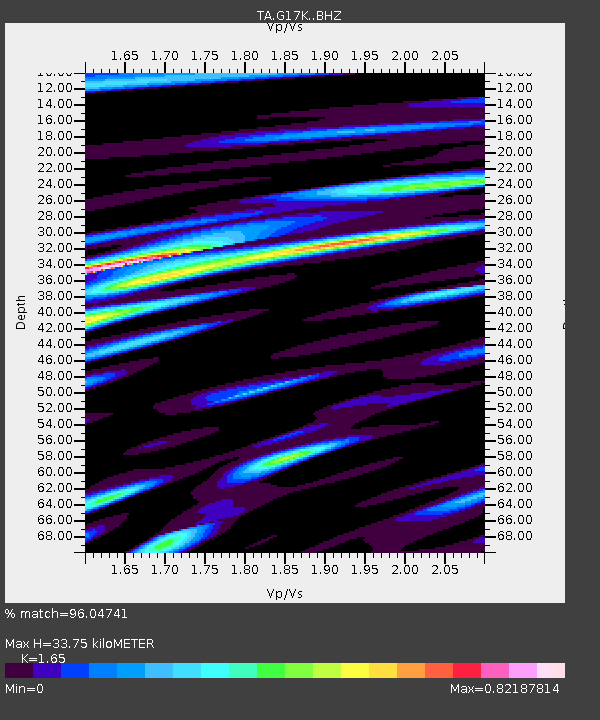
| Estimated Moho Depth: |
33.75 km |
| Estimated Crust Vp/Vs: |
1.65 |
| Assumed Crust Vp: |
6.276 km/s |
| Estimated Crust Vs: |
3.804 km/s |
| Estimated Crust Poisson's Ratio: |
0.21 |
|
| Radial Match: |
96.04741 % |
| Radial Bump: |
372 |
| Transverse Match: |
91.99238 % |
| Transverse Bump: |
400 |
| SOD ConfigId: |
21166931 |
| Insert Time: |
2020-06-18 09:02:33.465 +0000 |
| GWidth: |
2.5 |
| Max Bumps: |
400 |
| Tol: |
0.001 |
|

Signal To Noise
| Channel | StoN | STA | LTA |
| TA:G17K: :BHZ:20200604T09:01:03.075012Z | 89.99043 | 4.389314E-6 | 4.877534E-8 |
| TA:G17K: :BHN:20200604T09:01:03.075012Z | 6.6826296 | 3.3310167E-7 | 4.9845898E-8 |
| TA:G17K: :BHE:20200604T09:01:03.075012Z | 36.232037 | 1.4457927E-6 | 3.990371E-8 |
| Arrivals |
| Ps | 3.6 SECOND |
| PpPs | 14 SECOND |
| PsPs/PpSs | 17 SECOND |


