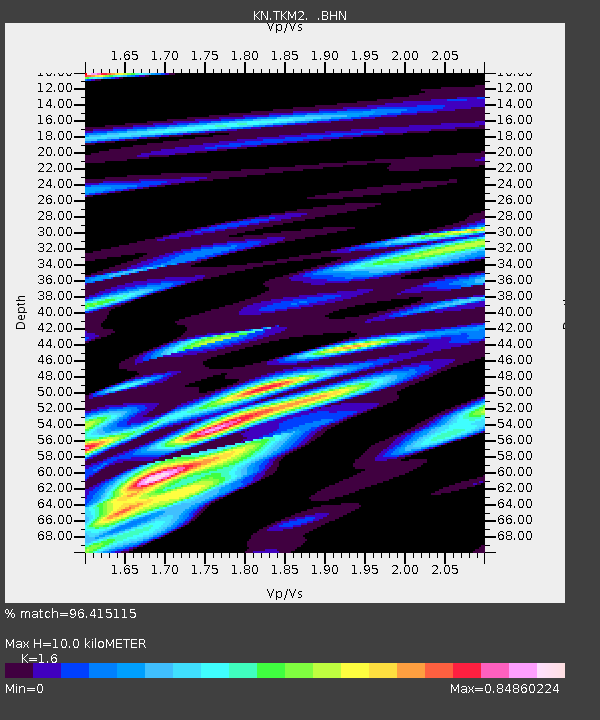
TKM2 KN.TKM2 - Earthquake Result Viewer
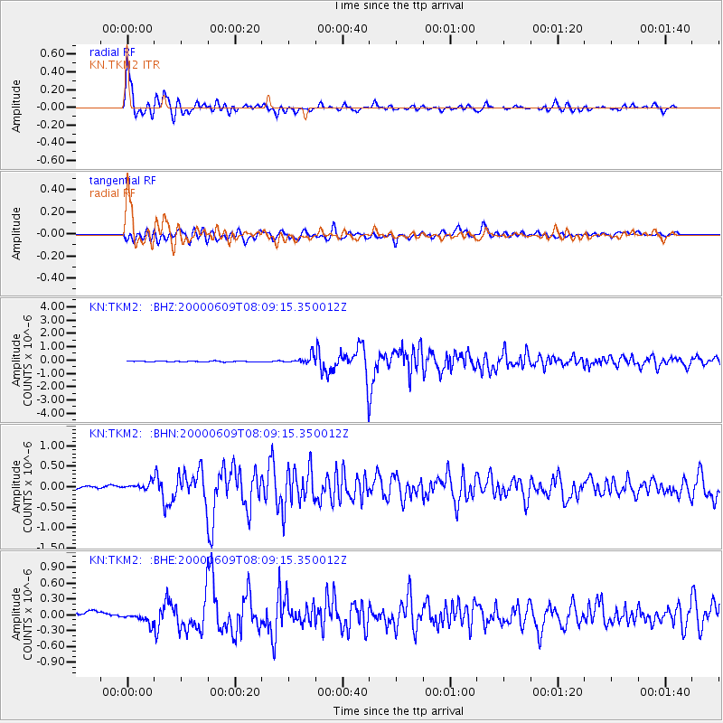
Earthquake location: Southern Sumatra, Indonesia
Earthquake latitude/longitude: -5.5/102.7
Earthquake time(UTC): 2000/06/09 (161) 08:00:24 GMT
Earthquake Depth: 33 km
Earthquake Magnitude: 5.8 MB, 5.8 MS, 6.0 MW, 6.0 MW
Earthquake Catalog/Contributor: WHDF/NEIC
Network: KN Kyrgyz Seismic Telemetry Network
Station: TKM2 KN.TKM2
Lat/Lon: 42.92 N/75.60 E
Elevation: 2020 m
Distance: 54.1 deg
Az: 335.628 deg
Baz: 146.002 deg
Ray Param: 0.065576985
Estimated Moho Depth: 10.0 km
Estimated Crust Vp/Vs: 1.60
Assumed Crust Vp: 6.306 km/s
Estimated Crust Vs: 3.941 km/s
Estimated Crust Poisson's Ratio: 0.18
Radial Match: 96.415115 %
Radial Bump: 400
Transverse Match: 83.10771 %
Transverse Bump: 400
SOD ConfigId: 3744
Insert Time: 2010-03-08 20:54:55.751 +0000
GWidth: 2.5
Max Bumps: 400
Tol: 0.001

Signal To Noise

ChannelStoNSTALTA
KN:TKM2: :BHN:20000609T08:09:15.350012Z2.55623919.7554775E-83.8163396E-8
KN:TKM2: :BHE:20000609T08:09:15.350012Z1.64839351.0262093E-76.225512E-8
KN:TKM2: :BHZ:20000609T08:09:15.350012Z10.3406053.2010314E-73.095594E-8
Arrivals
Ps1.0 SECOND
PpPs3.9 SECOND
PsPs/PpSs4.9 SECOND