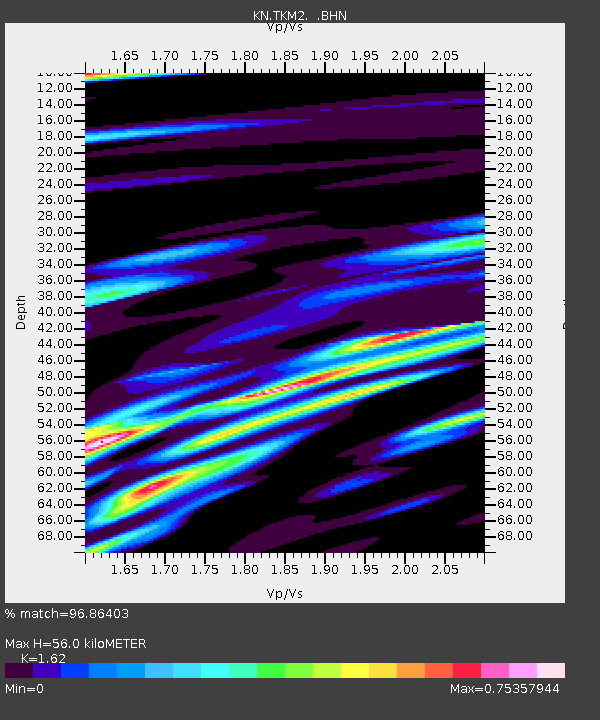
TKM2 KN.TKM2 - Earthquake Result Viewer
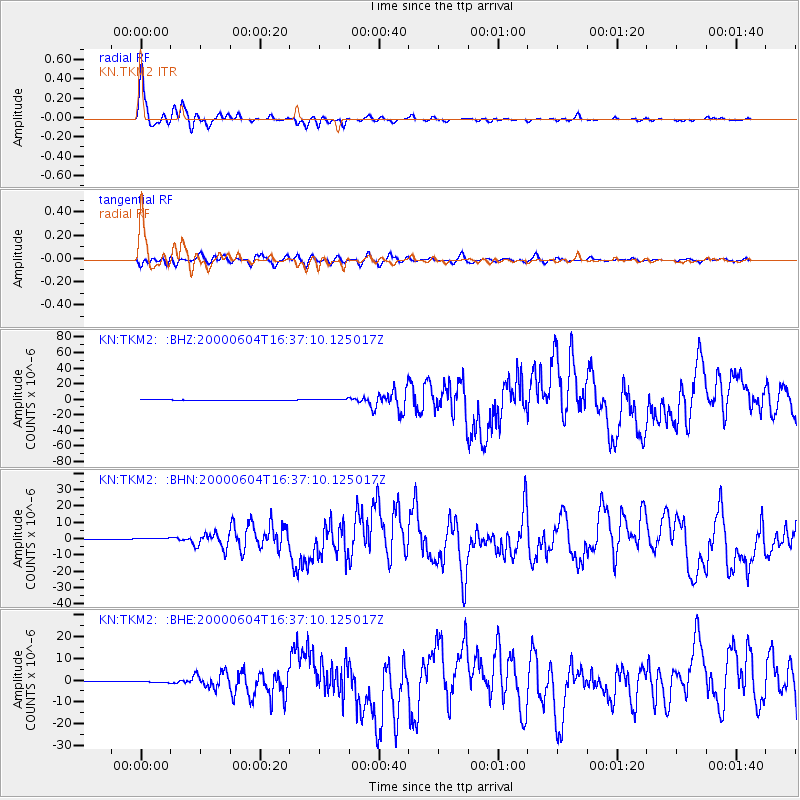
Earthquake location: Southern Sumatra, Indonesia
Earthquake latitude/longitude: -4.7/102.1
Earthquake time(UTC): 2000/06/04 (156) 16:28:26 GMT
Earthquake Depth: 33 km
Earthquake Magnitude: 6.8 MB, 8.0 MS, 7.9 MW, 7.7 MW
Earthquake Catalog/Contributor: WHDF/NEIC
Network: KN Kyrgyz Seismic Telemetry Network
Station: TKM2 KN.TKM2
Lat/Lon: 42.92 N/75.60 E
Elevation: 2020 m
Distance: 53.1 deg
Az: 335.828 deg
Baz: 146.25 deg
Ray Param: 0.06623264
Estimated Moho Depth: 56.0 km
Estimated Crust Vp/Vs: 1.62
Assumed Crust Vp: 6.306 km/s
Estimated Crust Vs: 3.893 km/s
Estimated Crust Poisson's Ratio: 0.19
Radial Match: 96.86403 %
Radial Bump: 400
Transverse Match: 87.20583 %
Transverse Bump: 400
SOD ConfigId: 3744
Insert Time: 2010-03-08 20:55:01.297 +0000
GWidth: 2.5
Max Bumps: 400
Tol: 0.001

Signal To Noise

ChannelStoNSTALTA
KN:TKM2: :BHN:20000604T16:37:10.125017Z4.6804264.3644482E-79.324896E-8
KN:TKM2: :BHE:20000604T16:37:10.125017Z2.02818782.4119888E-71.1892335E-7
KN:TKM2: :BHZ:20000604T16:37:10.125017Z4.025339.5367017E-72.3691726E-7
Arrivals
Ps5.8 SECOND
PpPs22 SECOND
PsPs/PpSs28 SECOND