You are here: Home > Network List > US - United States National Seismic Network Stations List
> Station AMTX Amarillo, Texas, USA > Earthquake Result Viewer
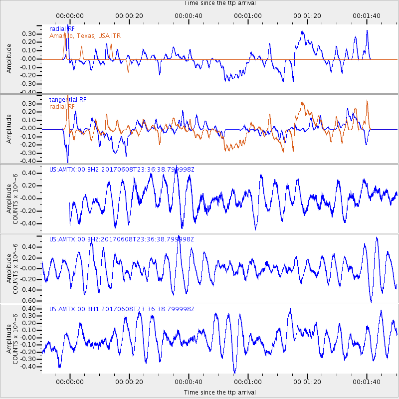
AMTX Amarillo, Texas, USA - Earthquake Result Viewer
*The percent match for this event was below the threshold and hence no stack was calculated.
| Earthquake location: |
Mariana Islands Region |
| Earthquake latitude/longitude: |
18.5/147.0 |
| Earthquake time(UTC): |
2017/06/08 (159) 23:23:43 GMT |
| Earthquake Depth: |
8.1 km |
| Earthquake Magnitude: |
5.6 mb |
| Earthquake Catalog/Contributor: |
NEIC PDE/us |
|
| Network: |
US United States National Seismic Network |
| Station: |
AMTX Amarillo, Texas, USA |
| Lat/Lon: |
34.53 N/101.41 W |
| Elevation: |
1010 m |
|
| Distance: |
96.3 deg |
| Az: |
50.588 deg |
| Baz: |
297.37 deg |
| Ray Param: |
$rayparam |
*The percent match for this event was below the threshold and hence was not used in the summary stack. |
|
| Radial Match: |
50.812656 % |
| Radial Bump: |
400 |
| Transverse Match: |
55.205833 % |
| Transverse Bump: |
400 |
| SOD ConfigId: |
2140511 |
| Insert Time: |
2017-06-22 15:18:54.427 +0000 |
| GWidth: |
2.5 |
| Max Bumps: |
400 |
| Tol: |
0.001 |
|
Signal To Noise
| Channel | StoN | STA | LTA |
| US:AMTX:00:BHZ:20170608T23:36:38.799998Z | 2.0192513 | 2.1658845E-7 | 1.07261755E-7 |
| US:AMTX:00:BH1:20170608T23:36:38.799998Z | 0.94573015 | 1.3978199E-7 | 1.4780326E-7 |
| US:AMTX:00:BH2:20170608T23:36:38.799998Z | 1.5795447 | 2.9778255E-7 | 1.8852431E-7 |
| Arrivals |
| Ps | |
| PpPs | |
| PsPs/PpSs | |


