You are here: Home > Network List > TA - USArray Transportable Network (new EarthScope stations) Stations List
> Station O14K Tigyukauivet Mountain, AK, USA > Earthquake Result Viewer
O14K Tigyukauivet Mountain, AK, USA - Earthquake Result Viewer
| Earthquake location: |
Halmahera, Indonesia |
| Earthquake latitude/longitude: |
2.9/128.2 |
| Earthquake time(UTC): |
2020/06/04 (156) 08:49:41 GMT |
| Earthquake Depth: |
127 km |
| Earthquake Magnitude: |
6.7 Mi |
| Earthquake Catalog/Contributor: |
NEIC PDE/at |
|
| Network: |
TA USArray Transportable Network (new EarthScope stations) |
| Station: |
O14K Tigyukauivet Mountain, AK, USA |
| Lat/Lon: |
59.25 N/161.26 W |
| Elevation: |
129 m |
|
| Distance: |
77.6 deg |
| Az: |
29.726 deg |
| Baz: |
254.553 deg |
| Ray Param: |
0.049904715 |
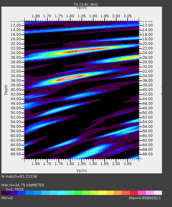
| Estimated Moho Depth: |
34.75 km |
| Estimated Crust Vp/Vs: |
1.79 |
| Assumed Crust Vp: |
6.24 km/s |
| Estimated Crust Vs: |
3.481 km/s |
| Estimated Crust Poisson's Ratio: |
0.27 |
|
| Radial Match: |
93.23236 % |
| Radial Bump: |
400 |
| Transverse Match: |
87.51557 % |
| Transverse Bump: |
373 |
| SOD ConfigId: |
21166931 |
| Insert Time: |
2020-06-18 09:03:49.911 +0000 |
| GWidth: |
2.5 |
| Max Bumps: |
400 |
| Tol: |
0.001 |
|

Signal To Noise
| Channel | StoN | STA | LTA |
| TA:O14K: :BHZ:20200604T09:00:52.275024Z | 38.499443 | 3.909443E-6 | 1.01545446E-7 |
| TA:O14K: :BHN:20200604T09:00:52.275024Z | 4.7600837 | 4.395558E-7 | 9.2342034E-8 |
| TA:O14K: :BHE:20200604T09:00:52.275024Z | 13.793486 | 1.1707227E-6 | 8.487505E-8 |
| Arrivals |
| Ps | 4.5 SECOND |
| PpPs | 15 SECOND |
| PsPs/PpSs | 20 SECOND |


