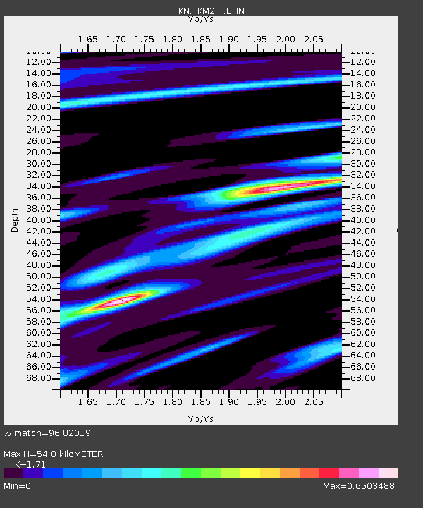
TKM2 KN.TKM2 - Earthquake Result Viewer
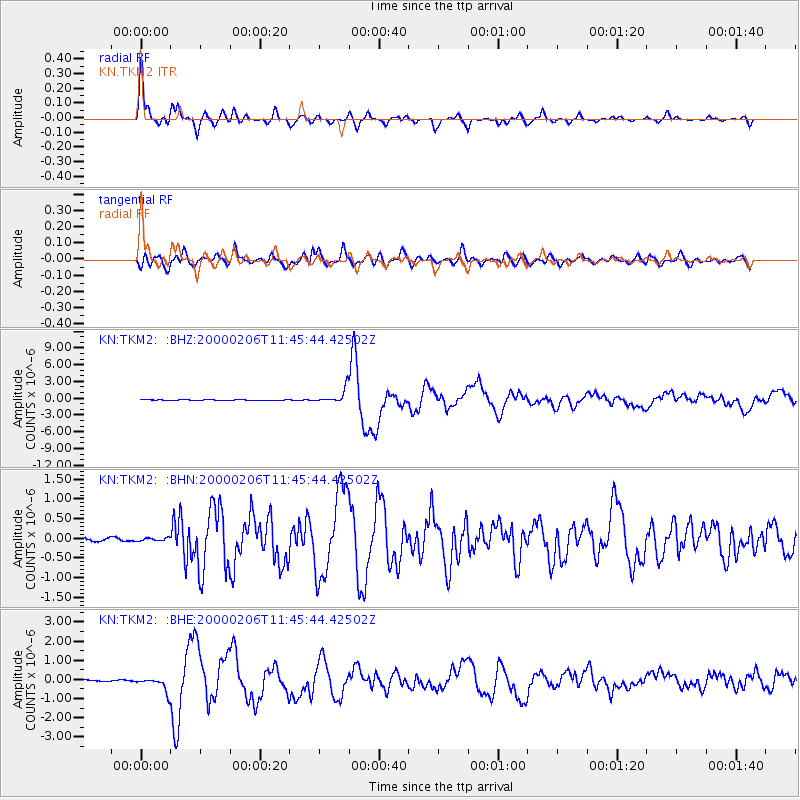
Earthquake location: New Britain Region, P.N.G.
Earthquake latitude/longitude: -5.8/150.9
Earthquake time(UTC): 2000/02/06 (037) 11:33:52 GMT
Earthquake Depth: 33 km
Earthquake Magnitude: 6.6 MB, 6.8 MS, 6.6 MW, 6.3 ME
Earthquake Catalog/Contributor: WHDF/NEIC
Network: KN Kyrgyz Seismic Telemetry Network
Station: TKM2 KN.TKM2
Lat/Lon: 42.92 N/75.60 E
Elevation: 2020 m
Distance: 83.3 deg
Az: 314.326 deg
Baz: 104.332 deg
Ray Param: 0.046258796
Estimated Moho Depth: 54.0 km
Estimated Crust Vp/Vs: 1.71
Assumed Crust Vp: 6.306 km/s
Estimated Crust Vs: 3.688 km/s
Estimated Crust Poisson's Ratio: 0.24
Radial Match: 96.82019 %
Radial Bump: 340
Transverse Match: 89.24679 %
Transverse Bump: 400
SOD ConfigId: 3744
Insert Time: 2010-03-08 20:55:13.680 +0000
GWidth: 2.5
Max Bumps: 400
Tol: 0.001

Signal To Noise

ChannelStoNSTALTA
KN:TKM2: :BHN:20000206T11:45:44.42502Z0.78765823.799506E-84.8238007E-8
KN:TKM2: :BHE:20000206T11:45:44.42502Z6.688983.6414616E-75.4439713E-8
KN:TKM2: :BHZ:20000206T11:45:44.42502Z19.7927281.298468E-66.560328E-8
Arrivals
Ps6.2 SECOND
PpPs23 SECOND
PsPs/PpSs29 SECOND