You are here: Home > Network List > KN - Kyrgyz Seismic Telemetry Network Stations List
> Station TKM2 KN.TKM2 > Earthquake Result Viewer
TKM2 KN.TKM2 - Earthquake Result Viewer
| Earthquake location: |
Samar, Philippines |
| Earthquake latitude/longitude: |
12.2/125.7 |
| Earthquake time(UTC): |
1995/05/24 (144) 20:21:25 GMT |
| Earthquake Depth: |
33 km |
| Earthquake Magnitude: |
5.7 MS, 5.4 MB |
| Earthquake Catalog/Contributor: |
WHDF/NEIC |
|
| Network: |
KN Kyrgyz Seismic Telemetry Network |
| Station: |
TKM2 KN.TKM2 |
| Lat/Lon: |
42.92 N/75.60 E |
| Elevation: |
2020 m |
|
| Distance: |
52.9 deg |
| Az: |
315.042 deg |
| Baz: |
109.873 deg |
| Ray Param: |
0.06639237 |
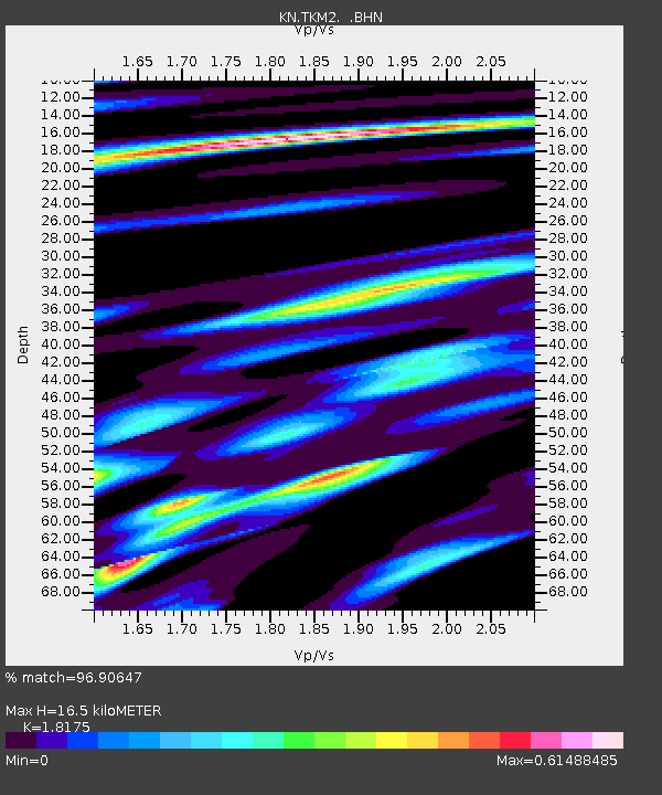
| Estimated Moho Depth: |
16.5 km |
| Estimated Crust Vp/Vs: |
1.82 |
| Assumed Crust Vp: |
6.306 km/s |
| Estimated Crust Vs: |
3.47 km/s |
| Estimated Crust Poisson's Ratio: |
0.28 |
|
| Radial Match: |
96.90647 % |
| Radial Bump: |
301 |
| Transverse Match: |
80.91557 % |
| Transverse Bump: |
400 |
| SOD ConfigId: |
4480 |
| Insert Time: |
2010-03-08 20:55:44.811 +0000 |
| GWidth: |
2.5 |
| Max Bumps: |
400 |
| Tol: |
0.001 |
|
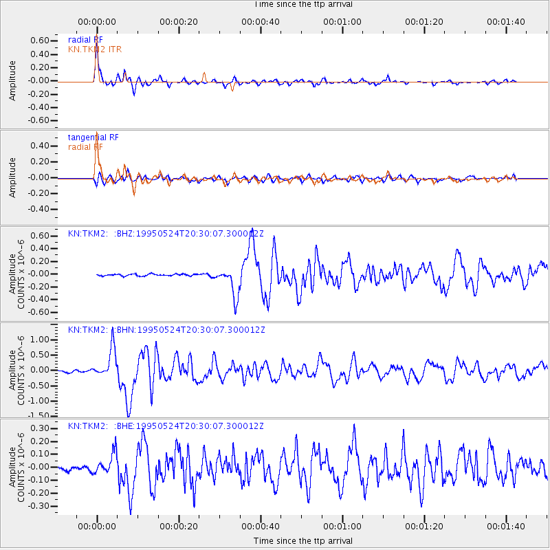
Signal To Noise
| Channel | StoN | STA | LTA |
| KN:TKM2: :BHN:19950524T20:30:07.300012Z | 16.24326 | 5.0097697E-7 | 3.0842145E-8 |
| KN:TKM2: :BHE:19950524T20:30:07.300012Z | 3.0862021 | 8.2843286E-8 | 2.6843116E-8 |
| KN:TKM2: :BHZ:19950524T20:30:07.300012Z | 16.897724 | 2.337113E-7 | 1.3830933E-8 |
| Arrivals |
| Ps | 2.3 SECOND |
| PpPs | 7.0 SECOND |
| PsPs/PpSs | 9.3 SECOND |


