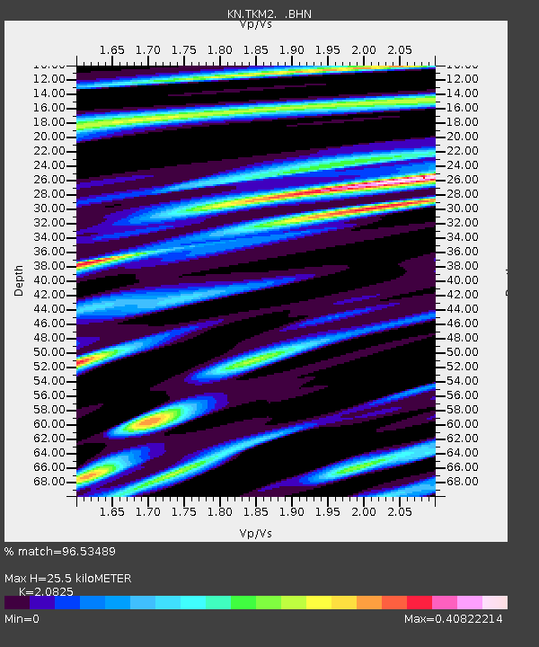
TKM2 KN.TKM2 - Earthquake Result Viewer
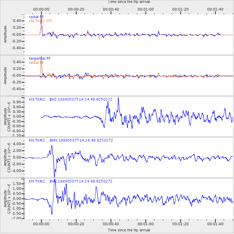
Earthquake location: Kodiak Island Region, Alaska
Earthquake latitude/longitude: 56.4/-152.9
Earthquake time(UTC): 1999/05/07 (127) 14:13:52 GMT
Earthquake Depth: 20 km
Earthquake Magnitude: 5.7 MB, 6.1 MS, 6.4 MW, 5.7 ME
Earthquake Catalog/Contributor: WHDF/NEIC
Network: KN Kyrgyz Seismic Telemetry Network
Station: TKM2 KN.TKM2
Lat/Lon: 42.92 N/75.60 E
Elevation: 2020 m
Distance: 72.9 deg
Az: 324.839 deg
Baz: 25.828 deg
Ray Param: 0.053328156
Estimated Moho Depth: 25.5 km
Estimated Crust Vp/Vs: 2.08
Assumed Crust Vp: 6.306 km/s
Estimated Crust Vs: 3.028 km/s
Estimated Crust Poisson's Ratio: 0.35
Radial Match: 96.53489 %
Radial Bump: 400
Transverse Match: 90.919655 %
Transverse Bump: 400
SOD ConfigId: 4480
Insert Time: 2010-03-08 20:56:06.861 +0000
GWidth: 2.5
Max Bumps: 400
Tol: 0.001

Signal To Noise

ChannelStoNSTALTA
KN:TKM2: :BHN:19990507T14:24:48.825027Z15.5604386.817869E-74.38154E-8
KN:TKM2: :BHE:19990507T14:24:48.825027Z5.7721922.5614432E-74.4375568E-8
KN:TKM2: :BHZ:19990507T14:24:48.825027Z2.8579231.0195646E-73.567502E-8
Arrivals
Ps4.5 SECOND
PpPs12 SECOND
PsPs/PpSs17 SECOND