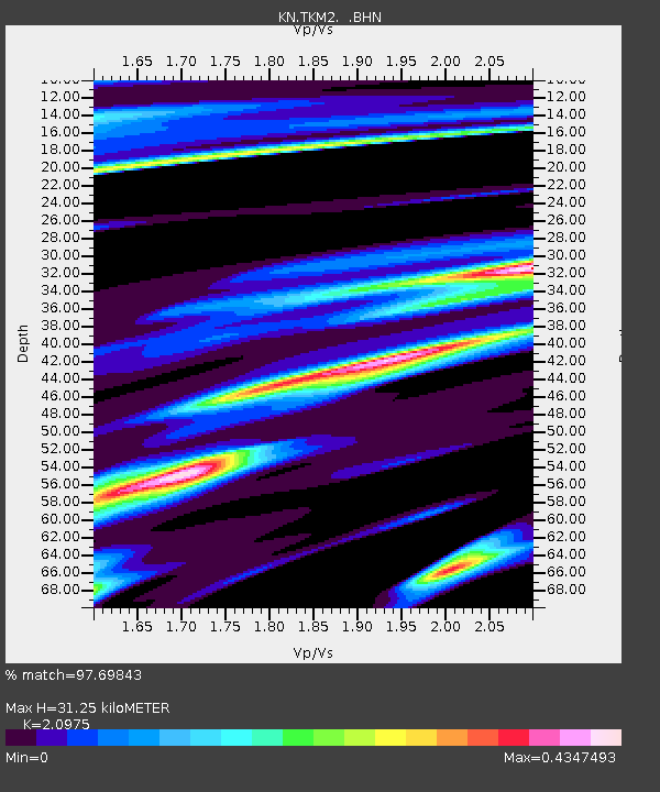
TKM2 KN.TKM2 - Earthquake Result Viewer
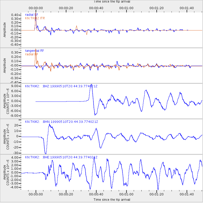
Earthquake location: New Britain Region, P.N.G.
Earthquake latitude/longitude: -5.2/150.9
Earthquake time(UTC): 1999/05/10 (130) 20:33:02 GMT
Earthquake Depth: 138 km
Earthquake Magnitude: 6.5 MB, 6.8 MS, 7.1 MW, 6.5 MB
Earthquake Catalog/Contributor: WHDF/NEIC
Network: KN Kyrgyz Seismic Telemetry Network
Station: TKM2 KN.TKM2
Lat/Lon: 42.92 N/75.60 E
Elevation: 2020 m
Distance: 82.8 deg
Az: 314.265 deg
Baz: 103.838 deg
Ray Param: 0.04631804
Estimated Moho Depth: 31.25 km
Estimated Crust Vp/Vs: 2.10
Assumed Crust Vp: 6.306 km/s
Estimated Crust Vs: 3.006 km/s
Estimated Crust Poisson's Ratio: 0.35
Radial Match: 97.69843 %
Radial Bump: 252
Transverse Match: 90.93053 %
Transverse Bump: 400
SOD ConfigId: 4480
Insert Time: 2010-03-08 20:56:12.616 +0000
GWidth: 2.5
Max Bumps: 400
Tol: 0.001

Signal To Noise

ChannelStoNSTALTA
KN:TKM2: :BHN:19990510T20:44:39.774021Z12.045738.8468806E-77.344413E-8
KN:TKM2: :BHE:19990510T20:44:39.774021Z0.97681327.857702E-88.044221E-8
KN:TKM2: :BHZ:19990510T20:44:39.774021Z6.1886333.8653002E-76.2458064E-8
Arrivals
Ps5.6 SECOND
PpPs15 SECOND
PsPs/PpSs21 SECOND