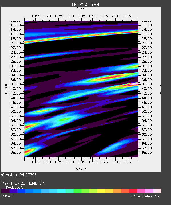
TKM2 KN.TKM2 - Earthquake Result Viewer
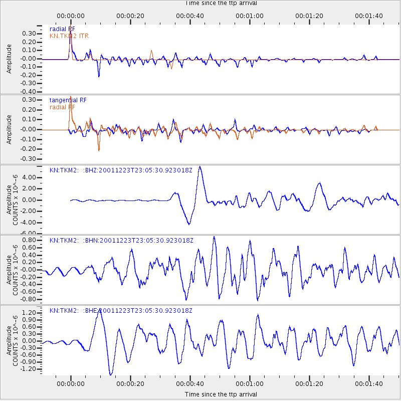
Earthquake location: Solomon Islands
Earthquake latitude/longitude: -9.6/159.5
Earthquake time(UTC): 2001/12/23 (357) 22:52:54 GMT
Earthquake Depth: 16 km
Earthquake Magnitude: 6.2 MB, 7.0 MS, 6.8 MW, 6.7 MW
Earthquake Catalog/Contributor: WHDF/NEIC
Network: KN Kyrgyz Seismic Telemetry Network
Station: TKM2 KN.TKM2
Lat/Lon: 42.92 N/75.60 E
Elevation: 2020 m
Distance: 92.1 deg
Az: 313.035 deg
Baz: 101.111 deg
Ray Param: 0.04151283
Estimated Moho Depth: 37.25 km
Estimated Crust Vp/Vs: 2.10
Assumed Crust Vp: 6.306 km/s
Estimated Crust Vs: 3.006 km/s
Estimated Crust Poisson's Ratio: 0.35
Radial Match: 96.27706 %
Radial Bump: 287
Transverse Match: 85.4701 %
Transverse Bump: 400
SOD ConfigId: 20082
Insert Time: 2010-03-08 20:56:15.630 +0000
GWidth: 2.5
Max Bumps: 400
Tol: 0.001

Signal To Noise

ChannelStoNSTALTA
KN:TKM2: :BHN:20011223T23:05:30.923018Z1.57196086.2347034E-83.9661952E-8
KN:TKM2: :BHE:20011223T23:05:30.923018Z2.00826291.6919603E-78.424994E-8
KN:TKM2: :BHZ:20011223T23:05:30.923018Z6.0252494.580431E-77.602061E-8
Arrivals
Ps6.6 SECOND
PpPs18 SECOND
PsPs/PpSs25 SECOND